⚠️ 本記事は令和8年(2026)8月6日時点の情報に基づきます。 令和8年熊本地震を受けた地震調査委員会の長期評価改訂が今後行われる見込みであり、確率値等は変更される可能性があります。
概要
日奈久断層帯八代海区間(ひなぐだんそうたいやつしろかいくかん)とは、日奈久断層帯(ひなぐだんそうたい)を構成する3区間のうち最も南西側に位置する区間で、熊本県葦北郡(あしきたぐん)芦北町(あしきたまち)の御立岬(おたちみさき)付近から八代海(やつしろかい)南部に至る、長さ約30kmの活断層です。
八代海区間は、その大部分が海域に位置することが最大の特徴です。陸域の活断層とは異なり地表での直接観察ができないため、反射法音波探査(はんしゃほうおんぱたんさ)や海上ボーリングといった海域特有の手法によって調査が進められてきました。
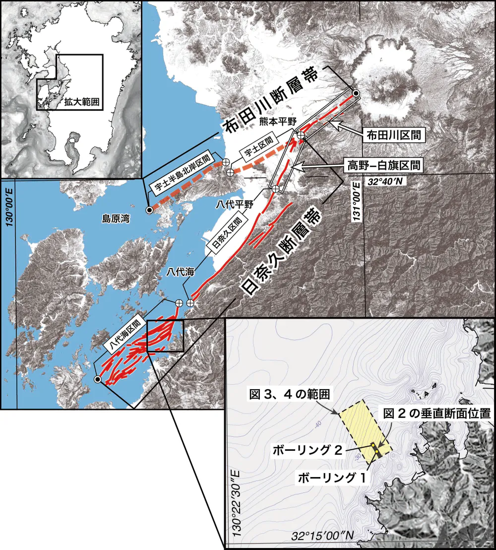
この区間は、平成28年(2016)熊本地震でも令和8年(2026)熊本地震でも活動しておらず、いわゆる「割れ残り」の状態にあります。地震調査研究推進本部は、今後30年以内にマグニチュード7.3程度の地震が発生する確率を「ほぼ0%〜16%」と評価し、切迫度が最も高い「Sランク」に位置づけています。
位置と範囲
八代海区間は、熊本県芦北町の御立岬付近を北東端とし、南西方向へ八代海南部まで延びています。長さは約30kmである可能性があるとされています。
日奈久断層帯全体は、上益城郡(かみましきぐん)益城町(ましきまち)木山付近から芦北町を経て八代海南部に至る全長約81kmの活断層帯で、次の3区間に区分されています。
| 区間名 | 範囲 | 長さ |
|---|---|---|
| 高野-白旗(たかの-しらはた)区間 | 益城町木山付近から宇城市(うきし)豊野町山崎付近まで | 約16km |
| 日奈久区間 | 宇城市豊野町山崎付近から御立岬付近まで | 約40km |
| 八代海区間 | 御立岬付近から八代海南部まで | 約30km(可能性) |
鹿児島大学准教授の井村隆介(いむらりゅうすけ)氏(地質学)は、日奈久断層帯を「益城町から出水市(いずみし)沖まで連なる長大な断層帯」と表現しており、八代海区間の南西端は鹿児島県北部の海域に及ぶとみられています。
海底活断層としての特徴
八代海区間は大部分が海底に位置するため、陸域の活断層で用いられるトレンチ調査(断層を横切る溝を掘って地層の食い違いを観察する方法)を適用できません。そのため、次のような海域特有の調査手法が用いられています。
反射法音波探査は、水中で発した音波が海底面およびその下の地層面で反射される性質を利用し、海底面下の地質構造を画像化する手法です。海上ボーリングは、海底面下の地層を貫いて円柱状の堆積物コア試料を採取し、地層が形成された年代や環境を直接調べる方法です。
産業技術総合研究所は、文部科学省から委託された「平成28年熊本地震を踏まえた総合的な活断層調査」(研究代表者:九州大学 清水洋(しみずひろし)氏)の一環として、八代海における海底活断層調査を実施しました。調査地点には、最も新しい時代の地層である沖積層(ちゅうせきそう)が厚く分布する津奈木(つなぎ)沖の海域が選定され、2地点で堆積物コア試料が採取されています。
「右ステップ」構造
この調査により、海底活断層の三次元的な形状が明らかになりました。海底活断層は、海上ボーリングを掘削した海域付近で鍵線状に折れ曲がっており、この構造は「右ステップ」と呼ばれます。右ステップした断層が右横ずれ運動をすると、断層付近に凹み(沈降域)が形成されます。
八代海の海底で確認された凹みは、このメカニズムによって生じたと推定されており、日奈久断層帯の陸上部分と同様に、海域においても水平方向のずれ(右横ずれ)が生じていることが示唆されています。
過去の活動
地震調査研究推進本部の長期評価によると、八代海区間は平均して1,100年から6,400年程度の間隔で活動した可能性があります。最新活動時期は約1,700年前以後、約900年前以前と推定され、活動時には3m程度のずれがあったと推定されますが、ずれの向きは不明です。
産業技術総合研究所による海底活断層調査では、反射法音波探査の垂直断面と海上ボーリングの結果に基づき、最近11,000年間に少なくとも4回の上下方向のずれを伴う地震が繰り返されたと推定されました。沖積層の反射面(ほぼ水平な縞状の模様)が海底活断層を挟んで上下にずれており、そのずれの量は深い(古い)地層ほど大きくなっていることから、断層活動が繰り返されてきたことが読み取れます。
天平16年(744)の肥後地震
八代海区間の最新活動については、天平(てんぴょう)16年(744)に発生した肥後(ひご)地震がこの区間の活動による可能性が指摘されています。
この地震については『続日本紀(しょくにほんぎ)』に記録が残されています。
《肥後国雷雨地震、八代・天草・葦北三郡官舍、并田二百九十余町、民家四百七十余区、人千五百二十余口、被水漂没、山崩二百八十余所、圧死人四十余人、并加賑恤》
現代語に要約すると、肥後国で雷雨と地震が発生し、八代・天草(あまくさ)・葦北の3郡において、官舎および田290余町(約290ヘクタール)、民家470余区、人1,520余人が水をかぶって漂没し、山崩れが280余か所発生、圧死者が40余人に上ったため、朝廷が救援物資(賑恤(しんじゅつ))を与えたという内容です。
東京大学地震研究所の村岸純(むらぎしじゅん)氏・佐竹健治(さたけけんじ)氏らによる歴史地震の研究では、被害があった3郡が日奈久断層にほぼ接していること、日奈久断層が八代平野東縁にあって八代海沿岸の平野部を沈降させてきた断層であることから、この史料が同断層の活動による地震を記録したものである可能性が論じられています。
【要注記】 天平16年の肥後地震が八代海区間の活動によるものであるかどうかは、あくまで「可能性がある」とされる段階の推定です。記録にある「水漂没」が津波によるものか、雷雨による洪水によるものかについても、複数の解釈があり得ます。
将来の地震発生の可能性
地震調査研究推進本部の長期評価では、八代海区間について次のように推定されています。
| 項目 | 内容 |
|---|---|
| 想定される地震規模 | マグニチュード7.3程度 |
| 30年以内の地震発生確率 | ほぼ0%〜16% |
| 相対的評価(ランク) | Sランク(3%以上、切迫度が最も高い区分) |
Sランクは、地震調査研究推進本部が主要活断層帯の切迫度を示すために設けた区分のうち最も高いもので、令和8年(2026)時点で全国31の活断層帯がこれに該当します。日奈久断層帯では、八代海区間と日奈久区間の2区間がSランクに分類されています。
なお、地震調査研究推進本部は確率値の解釈について、値が小さく見えても地震が発生しないことを意味するものではないと注意を促しています。同本部によれば、平成7年(1995)兵庫県南部地震の発生直前の確率値は0.02%〜8%、平成28年(2016)熊本地震の場合はほぼ0%〜0.9%でした。
連動の可能性
日奈久断層帯の3区間は別々に活動すると推定されていますが、全体が同時に活動する可能性も否定できないとされ、その場合にはマグニチュード7.7から8.0程度の地震が発生する可能性があります。さらに、日奈久断層帯の全体と布田川断層帯(ふたがわだんそうたい)の布田川区間が同時に活動する場合には、マグニチュード7.8から8.2程度の地震が発生する可能性が指摘されています。
2つの熊本地震における「割れ残り」
八代海区間は、近年発生した2つの震度7の地震のいずれにおいても活動していません。
- 平成28年(2016)熊本地震:布田川断層帯の布田川区間と、日奈久断層帯の高野-白旗区間の一部(北端から約6km)が活動しました。日奈久区間および八代海区間は活動しなかったと評価されています。
- 令和8年(2026)熊本地震:地震調査委員会の評価(令和8年7月29日臨時会合)によると、日奈久区間の北東部と高野-白旗区間の一部の計約30kmが活動したと推定されています。日奈久区間にはなお割れ残りがあり、八代海区間は今回も活動していないとされています。
地震調査委員会の小原一成(こはらかずなり)委員長(東京大学名誉教授)は、令和8年7月29日の記者会見で「まだ割れ残っている部分がある。将来的に地震を引き起こす可能性は十分ある」と注意を呼びかけました。
井村隆介氏は、令和8年熊本地震で活動した区間についても以前から「ポテンシャルが高い」と評価されていた部分であり、その30年確率は「1パーセントとか2パーセントとかそれぐらい」とされていたにもかかわらず現実に地震が発生したと指摘しています。確率値の低さが安全を意味しないことを示す事例といえます。
津波の可能性
八代海区間が大部分を海域に持つことから、この区間が活動した場合には津波の発生が懸念されています。
井村隆介氏は令和8年8月、八代海区間が動いた場合には鹿児島県北部の出水市や長島町(ながしまちょう)の沿岸に津波が及ぶ可能性があると指摘し、地震の揺れだけでなく津波リスクも視野に入れた備えが必要だと述べています。
なお、令和8年(2026)熊本地震の際にも有明(ありあけ)・八代海に津波注意報が発表されました(令和8年7月28日16時29分発表、同日18時10分解除)。この地震で活動したのは主に陸域の日奈久区間北東部でしたが、八代海に面した地域では地震に伴う津波への警戒が現実の課題となっています。
阿蘇地域との関係
八代海区間は阿蘇地域から100km近く離れた熊本県南部の海域に位置しており、この区間が単独で活動した場合、阿蘇地域が震源域に含まれることはありません。ただし、次の2点において阿蘇地域とも無関係ではないと考えられます。
第一に、八代海区間は日奈久断層帯の一部であり、日奈久断層帯は北端で布田川断層帯と接しています。布田川断層帯は阿蘇外輪山(あそがいりんざん)の西側斜面を起点としており、平成28年(2016)熊本地震では破壊域が阿蘇外輪山(カルデラ)にまで達しました。断層帯全体が連動した場合、阿蘇地域も強い揺れに見舞われる可能性があります。
第二に、マグニチュード7.7〜8.2程度という連動時の想定規模は、平成28年熊本地震(M7.3)や令和8年熊本地震(M7.1)を大きく上回ります。この規模の地震が発生した場合、震源から離れた阿蘇地域でも相応の揺れが想定されます。
阿蘇ジオパークの視点からは、八代海区間を含む日奈久断層帯・布田川断層帯は、阿蘇カルデラの形成と同じ地殻変動場のなかで生じた地質構造として位置づけられます。
よくある質問
Q. 日奈久断層帯八代海区間とはどこにありますか? A. 熊本県芦北町の御立岬付近から八代海南部に至る、長さ約30kmの活断層です。日奈久断層帯を構成する3区間のうち最も南西側に位置し、大部分が海域にあります。
Q. なぜ「割れ残り」と呼ばれるのですか? A. 平成28年(2016)熊本地震でも令和8年(2026)熊本地震でも、この区間は活動しなかったためです。活断層帯のなかでまだずれ動いていない区間を指して「割れ残り」と表現されます。
Q. 地震が起きる確率はどのくらいですか? A. 地震調査研究推進本部は、今後30年以内にマグニチュード7.3程度の地震が発生する確率を「ほぼ0%〜16%」と評価し、切迫度が最も高い「Sランク」に位置づけています。ただし、この評価は令和8年熊本地震の発生を反映する前のものであり、今後改訂される見込みです。
Q. 過去にはいつ活動しましたか? A. 最新活動時期は約1,700年前以後、約900年前以前と推定されており、天平16年(744)の肥後地震がこの区間の活動による可能性が指摘されています。また、海底活断層調査により、最近11,000年間に少なくとも4回活動したと推定されています。
Q. 津波の危険はありますか? A. 大部分が海域にあるため、この区間が活動した場合には津波の発生が懸念されています。専門家からは、鹿児島県の出水市や長島町の沿岸に津波が及ぶ可能性が指摘されています。
Q. 阿蘇地域に影響はありますか? A. 八代海区間が単独で活動した場合、阿蘇地域が震源域に含まれることはありません。ただし、日奈久断層帯全体や布田川断層帯と連動した場合はマグニチュード7.7〜8.2程度の地震となる可能性があり、阿蘇地域でも強い揺れが想定されます。
関連項目
参考文献
- 地震調査研究推進本部地震調査委員会「布田川断層帯・日奈久断層帯の評価(一部改訂)」(平成25年〈2013〉)
- 地震調査研究推進本部「布田川断層帯・日奈久断層帯」(活断層の長期評価) https://www.jishin.go.jp/regional_seismicity/rs_katsudanso/f093_futagawa_hinagu/
- 地震調査研究推進本部「長期評価結果一覧」(活断層及び海溝型地震の長期評価結果一覧、2026年1月1日での算定/令和8年1月14日公表) https://www.jishin.go.jp/evaluation/long_term_evaluation/lte_summary/
- 地震調査研究推進本部「熊本県日奈久断層帯(海域部)における海底活断層調査」(広報誌『地震本部ニュース』平成30年〈2018〉夏号) https://www.jishin.go.jp/resource/column/column_18sum_p04/
- 『続日本紀』天平16年(744)肥後国地震の記事
- 村岸純・佐竹健治「九州中部地方の歴史地震」(東京大学地震研究所、2016年)
- 楮原京子ほか「布田川・日奈久断層帯海域部における高分解能マルチチャンネル音波探査」『活断層・古地震研究報告』第11号、産業技術総合研究所地質調査総合センター、2011年、273-294頁
- 後藤秀昭・千田昇『国土地理院技術資料 D1-No.914 1:25,000活断層図 布田川・日奈久断層帯とその周辺「八代 改訂版」「日奈久」解説書』国土地理院 https://www.gsi.go.jp/common/000202326.pdf
- 鹿児島ニュースKTS「まだ動いていない断層が怖い 日奈久断層『八代海区間』が動けば出水・長島に津波の恐れも 専門家が警鐘【鹿児島】」(2026年8月3日、鹿児島大学・井村隆介准教授へのインタビュー)
- MBSニュース「【地震】あなたの住んでいる地域の『リスク評価』は?今後30年の地震発生確率が3%以上『Sランク』と評価されたのは31の活断層帯…今回の熊本地震の震源近い『日奈久断層帯』も『S』」(2026年7月)
- 毎日新聞「『震源の日奈久断層にまだ割れ残り』 切迫度Sランク 熊本地震」(2026年7月30日)
- 共同通信「震源断層30キロ活動と推定 調査委員長、割れ残り指摘」(2026年7月29日)
- 国土地理院「令和8年(2026年)熊本地震に関する情報」 https://www.gsi.go.jp/BOUSAI/20260728_kumamoto_earthquake.html
- Wikipedia「布田川・日奈久断層帯」
Hinagu Fault Zone — Yatsushiro-kai Section
⚠️ This article reflects information as of August 6, 2026. The Earthquake Research Committee is expected to revise its long-term evaluation figures following the 2026 Kumamoto Earthquake, and the probability values below may change.
Overview
The Yatsushiro-kai section (八代海区間, Yatsushiro-kai kukan) is the southwesternmost of the three sections that make up the Hinagu Fault Zone (日奈久断層帯, Hinagu Dansōtai). It is an active fault approximately 30 km long, running from the vicinity of Cape Otachi-misaki in Ashikita Town, Ashikita District, Kumamoto Prefecture, to the southern part of the Yatsushiro Sea.
The section's defining feature is that most of it lies underwater. Unlike active faults on land, it cannot be observed directly at the surface, so it has been investigated using techniques specific to marine surveys, such as reflection seismic surveys and offshore boring.
Source: Headquarters for Earthquake Research Promotion
This section did not rupture in either the 2016 Kumamoto Earthquake or the 2026 Kumamoto Earthquake, and is considered to remain an unruptured segment ("residual gap"). The Headquarters for Earthquake Research Promotion estimates the probability of a magnitude-7.3-class earthquake occurring within the next 30 years at "nearly 0% to 16%," placing it in Rank S, the highest urgency category.
Location and Extent
The Yatsushiro-kai section begins near Cape Otachi-misaki in Ashikita Town, Kumamoto Prefecture, at its northeastern end, and extends southwestward into the southern Yatsushiro Sea. Its length is estimated at approximately 30 km, though this figure remains provisional.
The Hinagu Fault Zone as a whole is an active fault zone roughly 81 km long, running from the vicinity of Kiyama in Mashiki Town, Kamimashiki District, through Ashikita Town to the southern Yatsushiro Sea. It is divided into the following three sections:
| Section | Extent | Length |
|---|---|---|
| Takano–Shirahata section | From near Kiyama, Mashiki Town, to near Yamasaki, Toyono-machi, Uki City | approx. 16 km |
| Hinagu section | From near Yamasaki, Toyono-machi, Uki City, to near Cape Otachi-misaki | approx. 40 km |
| Yatsushiro-kai section | From near Cape Otachi-misaki to the southern Yatsushiro Sea | approx. 30 km (provisional) |
Associate Professor Ryusuke Imura of Kagoshima University (geology) has described the Hinagu Fault Zone as "a long fault zone extending from Mashiki Town to the waters off Izumi City," and the southwestern end of the Yatsushiro-kai section is thought to reach into the sea off northern Kagoshima Prefecture.
Characteristics as a Submarine Active Fault
Because most of the Yatsushiro-kai section lies on the seafloor, trenching surveys — the standard method used for active faults on land, in which a trench is dug across the fault to observe offsets in the sediment layers — cannot be applied. Instead, the following marine-specific survey methods have been used.
Reflection seismic surveys use sound waves emitted underwater, which reflect off the seafloor and the sediment layers beneath it, to image the subsurface geological structure. Offshore boring involves drilling a cylindrical core sample through the sediment layers beneath the seafloor to directly examine the age and depositional environment of the strata.
The National Institute of Advanced Industrial Science and Technology (AIST) conducted a submarine active-fault survey of the Yatsushiro Sea as part of "Comprehensive Active Fault Research in Light of the 2016 Kumamoto Earthquake," a project commissioned by the Ministry of Education, Culture, Sports, Science and Technology (lead researcher: Hiroshi Shimizu, Kyushu University). The survey area, off the coast of Tsunagi, was selected because it contains a thick deposit of alluvium, the youngest stratigraphic layer, and sediment core samples were collected at two points.
The "Right-Step" Structure
The survey revealed the three-dimensional shape of the submarine active fault. Near the site of the offshore boring, the fault bends in a key-shaped pattern, a configuration known as a "right step." When a right-stepping fault undergoes right-lateral strike-slip motion, a depression (subsidence zone) forms near the fault.
The depression observed on the seafloor of the Yatsushiro Sea is believed to have formed through this mechanism, suggesting that horizontal displacement (right-lateral slip) occurs in the offshore portion of the Hinagu Fault Zone, just as it does on land.
Past Activity
According to the long-term evaluation by the Headquarters for Earthquake Research Promotion, the Yatsushiro-kai section may have been active at intervals averaging between 1,100 and 6,400 years. Its most recent activity is estimated to have occurred sometime after roughly 1,700 years ago and before roughly 900 years ago, with an estimated displacement of about 3 m during that event, though the direction of displacement is unknown.
The AIST submarine survey, based on vertical cross-sections from reflection seismic surveys and offshore boring results, estimated that at least four earthquakes involving vertical displacement occurred over the past 11,000 years. The reflective surfaces of the alluvium (near-horizontal banded patterns) are offset vertically across the submarine fault, with the amount of offset increasing in the deeper (older) layers — evidence that the fault has been repeatedly active over time.
The Higo Earthquake of 744 (Tenpyō 16)
It has been suggested that the most recent activity of the Yatsushiro-kai section may correspond to the Higo earthquake of 744 (Tenpyō 16).
This earthquake is recorded in the Shoku Nihongi (続日本紀), an early Japanese chronicle:
"In Higo Province, thunder, heavy rain, and an earthquake struck. In the three districts of Yatsushiro, Amakusa, and Ashikita, over 290 chō of government and private paddy fields and more than 470 private dwellings were submerged and swept away, affecting more than 1,520 people. Landslides occurred at over 280 locations, and more than 40 people were crushed to death. The court subsequently provided relief supplies."
In summary: thunder, heavy rain, and an earthquake struck Higo Province, and in the three districts of Yatsushiro, Amakusa, and Ashikita, roughly 290 chō (about 290 hectares) of government and private paddy fields, more than 470 private dwellings, and more than 1,520 people were submerged or swept away by water; landslides occurred at more than 280 locations; and more than 40 people died, crushed by the landslides — prompting the imperial court to provide relief supplies.
Research on historical earthquakes by Jun Muragishi and Kenji Satake of the Earthquake Research Institute, University of Tokyo, has argued that this record may describe an earthquake caused by the Hinagu Fault, based on the facts that the three affected districts lie almost directly along the fault, and that the Hinagu Fault runs along the eastern margin of the Yatsushiro Plain and has historically caused subsidence in the coastal lowlands of the Yatsushiro Sea.
Note: Whether the 744 Higo earthquake was actually caused by activity on the Yatsushiro-kai section remains, at this stage, only a possibility rather than a confirmed conclusion. There are also multiple interpretations of whether the "submergence by water" described in the record was caused by a tsunami or by flooding from the thunderstorm.
Likelihood of a Future Earthquake
The long-term evaluation by the Headquarters for Earthquake Research Promotion gives the following estimates for the Yatsushiro-kai section:
| Item | Estimate |
|---|---|
| Expected earthquake magnitude | Approximately M7.3 |
| Probability of occurrence within 30 years | Nearly 0% to 16% |
| Relative ranking | Rank S (3% or higher; the highest-urgency category) |
Rank S is the highest of the categories the Headquarters for Earthquake Research Promotion uses to indicate the urgency of Japan's major active fault zones; as of 2026, 31 active fault zones nationwide fall into this category. Within the Hinagu Fault Zone, both the Yatsushiro-kai section and the Hinagu section are classified as Rank S.
The Headquarters for Earthquake Research Promotion cautions that a low probability value does not mean an earthquake will not occur. According to the Headquarters, the estimated probability shortly before the 1995 Southern Hyogo Prefecture Earthquake was 0.02% to 8%, and shortly before the 2016 Kumamoto Earthquake it was nearly 0% to 0.9%.
Possibility of a Linked Rupture
While the three sections of the Hinagu Fault Zone are estimated to rupture independently, the possibility that all three could rupture simultaneously cannot be ruled out; in that case, an earthquake of magnitude 7.7 to 8.0 could occur. Furthermore, if the entire Hinagu Fault Zone ruptured together with the Futagawa section of the Futagawa Fault Zone, an earthquake of magnitude 7.8 to 8.2 has been suggested as possible.
The "Unruptured Segment" in Two Kumamoto Earthquakes
The Yatsushiro-kai section has not ruptured in either of the two recent magnitude-7-class (JMA seismic intensity 7) earthquakes to strike the region.
- 2016 Kumamoto Earthquake: The Futagawa section of the Futagawa Fault Zone and part of the Takano–Shirahata section of the Hinagu Fault Zone (about 6 km from its northern end) ruptured. The Hinagu section and the Yatsushiro-kai section are assessed as not having been active.
- 2026 Kumamoto Earthquake: According to the Earthquake Research Committee's assessment (from its extraordinary meeting on July 29, 2026), the northeastern part of the Hinagu section and part of the Takano–Shirahata section — roughly 30 km combined — are estimated to have ruptured. The Hinagu section still retains an unruptured portion, and the Yatsushiro-kai section is assessed as not having ruptured this time either.
At a press conference on July 29, 2026, Kazunari Kohara, chair of the Earthquake Research Committee and professor emeritus at the University of Tokyo, cautioned that "an unruptured portion still remains, and there is a real possibility it could cause an earthquake in the future."
Ryusuke Imura has noted that the section that ruptured in the 2026 Kumamoto Earthquake had previously been assessed as having "high potential," with a 30-year probability described as "around 1% to 2%" — and yet the earthquake occurred despite that low figure, illustrating that a low probability value does not indicate safety.
Tsunami Potential
Because most of the Yatsushiro-kai section lies underwater, concern has been raised that a rupture of this section could generate a tsunami.
In August 2026, Ryusuke Imura noted that if the Yatsushiro-kai section were to rupture, a tsunami could reach the coasts of Izumi City and Nagashima Town in northern Kagoshima Prefecture, and stated that preparedness should account for tsunami risk in addition to ground shaking.
During the 2026 Kumamoto Earthquake, a tsunami advisory was in fact issued for the Ariake Sea and Yatsushiro Sea (issued at 16:29 on July 28, 2026, and lifted at 18:10 the same day). Although the section that ruptured in that earthquake was primarily the onshore northeastern part of the Hinagu section, tsunami preparedness remains an active concern for communities facing the Yatsushiro Sea.
Relationship to the Aso Region
The Yatsushiro-kai section lies in the waters of southern Kumamoto Prefecture, nearly 100 km from the Aso region. If this section were to rupture on its own, the Aso region would not fall within the earthquake's source area. Even so, the section is connected to the Aso region in two respects.
First, the Yatsushiro-kai section is part of the Hinagu Fault Zone, which connects at its northern end to the Futagawa Fault Zone. The Futagawa Fault Zone originates on the western flank of the Aso outer rim (Aso-gairinzan), and in the 2016 Kumamoto Earthquake, the zone of rupture extended as far as the Aso caldera. If the fault zones were to rupture together, the Aso region could experience strong shaking as well.
Second, the estimated magnitude of a linked rupture — M7.7 to 8.2 — would substantially exceed both the 2016 Kumamoto Earthquake (M7.3) and the 2026 Kumamoto Earthquake (M7.1). An earthquake of this scale would likely produce significant shaking even in the Aso region, despite the distance from the source.
From the perspective of the Aso UNESCO Global Geopark, the Hinagu and Futagawa fault zones — including the Yatsushiro-kai section — are understood as geological structures that formed within the same regional crustal deformation field that produced the Aso caldera.
Frequently Asked Questions
Q. Where is the Yatsushiro-kai section of the Hinagu Fault Zone? A. It is an active fault approximately 30 km long, running from near Cape Otachi-misaki in Ashikita Town, Kumamoto Prefecture, to the southern Yatsushiro Sea. It is the southwesternmost of the three sections of the Hinagu Fault Zone, and most of it lies underwater.
Q. Why is it called an "unruptured segment"? A. Because it did not rupture in either the 2016 or the 2026 Kumamoto Earthquake. The term refers to a portion of an active fault zone that has not yet slipped.
Q. What is the probability of an earthquake occurring? A. The Headquarters for Earthquake Research Promotion estimates the probability of a magnitude-7.3-class earthquake within the next 30 years at "nearly 0% to 16%," placing it in Rank S, the highest-urgency category. This assessment, however, predates the 2026 Kumamoto Earthquake and is expected to be revised.
Q. When was it last active? A. Its most recent activity is estimated to have occurred sometime after about 1,700 years ago and before about 900 years ago. It has been suggested that the 744 Higo earthquake may correspond to this activity. A submarine survey also estimated at least four ruptures over the past 11,000 years.
Q. Is there a tsunami risk? A. Because most of the section lies underwater, a rupture could generate a tsunami. Experts have specifically noted the possibility of a tsunami reaching the coasts of Izumi City and Nagashima Town in Kagoshima Prefecture.
Q. Could this affect the Aso region? A. If the Yatsushiro-kai section ruptured alone, the Aso region would not be within the source area. However, a linked rupture involving the entire Hinagu Fault Zone or the Futagawa Fault Zone could reach magnitude 7.7–8.2, in which case strong shaking would also be expected in the Aso region.
References
- Earthquake Research Committee, Headquarters for Earthquake Research Promotion, "Evaluation of the Futagawa and Hinagu Fault Zones (Partial Revision)" (2013)
- Headquarters for Earthquake Research Promotion, "Futagawa Fault Zone / Hinagu Fault Zone" (Long-term evaluation of active faults) — https://www.jishin.go.jp/regional_seismicity/rs_katsudanso/f093_futagawa_hinagu/
- Headquarters for Earthquake Research Promotion, "Summary List of Long-Term Evaluation Results" (active faults and subduction-zone earthquakes; calculated as of January 1, 2026; published January 14, 2026) — https://www.jishin.go.jp/evaluation/long_term_evaluation/lte_summary/
- Headquarters for Earthquake Research Promotion, "Submarine Active Fault Survey of the Hinagu Fault Zone (Offshore Portion), Kumamoto Prefecture" (Jishin Honbu News, Summer 2018) — https://www.jishin.go.jp/resource/column/column_18sum_p04/
- Shoku Nihongi, entry for the Higo Province earthquake of 744 (Tenpyō 16)
- Jun Muragishi and Kenji Satake, "Historical Earthquakes in Central Kyushu" (Earthquake Research Institute, University of Tokyo, 2016)
- Kyoko Kajiwara et al., "High-Resolution Multichannel Seismic Survey of the Offshore Portion of the Futagawa–Hinagu Fault Zone," Active Fault and Paleoearthquake Researches, No. 11, Geological Survey of Japan, AIST, 2011, pp. 273–294
- Hideaki Goto and Noboru Chida, Geospatial Information Authority of Japan Technical Report D1-No.914: 1:25,000 Active Fault Map — Futagawa/Hinagu Fault Zone and Surrounding Area, "Yatsushiro (Revised)" and "Hinagu" Explanatory Notes, Geospatial Information Authority of Japan — https://www.gsi.go.jp/common/000202326.pdf
- KTS Kagoshima News, "The Fault That Hasn't Moved Yet Is the Scary One — If the Hinagu Fault's 'Yatsushiro-kai Section' Moves, Izumi and Nagashima Could Face Tsunami Risk, Expert Warns [Kagoshima]" (August 3, 2026; interview with Associate Professor Ryusuke Imura, Kagoshima University)
- MBS News, "Earthquake: What Is the Risk Assessment for Your Area? 31 Active Fault Zones Rated 'Rank S' for 30-Year Occurrence Probability of 3% or Higher — Including the Hinagu Fault Zone, Close to the Epicenter of the Recent Kumamoto Earthquake" (July 2026)
- Mainichi Shimbun, "'Unruptured Portion Remains on the Hinagu Fault, the Source of the Earthquake' — Rank S Urgency, Kumamoto Earthquake" (July 30, 2026)
- Kyodo News, "Approximately 30 km of Source Fault Estimated to Have Ruptured; Committee Chair Notes Unruptured Portion Remains" (July 29, 2026)
- Geospatial Information Authority of Japan, "Information on the 2026 Kumamoto Earthquake" — https://www.gsi.go.jp/BOUSAI/20260728_kumamoto_earthquake.html
- Wikipedia, "Futagawa–Hinagu Fault Zone" (Japanese)
Translated from the Japanese-language AsoPedia article "日奈久断層帯八代海区間." Last updated (Japanese source): August 9, 2026.