⚠️ この記事は進行中の災害を扱っています。 記載内容は令和8年(2026)8月27日時点で判明している情報に基づく更新版です(初稿:7月29日、以後7月30日・7月31日・8月3日〜8月9日・8月17日に更新)。発災から1か月が経過し、更新頻度をさらに下げています。人的被害・避難状況等の数値は今後も変動します。各数値には情報源と時点を付記していますが、機関ごとに集計時刻・集計対象が異なるため、単純な合算・比較はできません。最新情報での確認・更新が必要です。
概要
令和8年(2026)熊本地震(くまもとじしん)とは、令和8年(2026)7月28日16時27分に熊本県熊本地方を震源として発生した地震です。気象庁マグニチュードは7.1、震源の深さは16km(暫定値)で、熊本県宇城市(うきし)と八代郡(やつしろぐん)氷川町(ひかわちょう)で最大震度7を観測しました。気象庁はこの地震を「令和8年熊本地震」と命名しました。
国内で震度7を観測する地震は、令和6年(2024)1月の能登半島地震以来2年6か月ぶりです。熊本県内で震度7を観測するのは、平成28年(2016)熊本地震(4月14日・16日)以来10年3か月ぶりであり、県内では3回目の震度7観測となりました。この地震により有明(ありあけ)・八代海(やつしろかい)に津波注意報が発表されました。国土地理院の解析により、今回の地震は平成28年(2016)熊本地震で活動しなかった日奈久断層帯(ひなぐだんそうたい)の一部区間が動いたものと確認されています(詳細は後述)。令和8年8月24日時点で、死者は災害関連死の疑いおよび関連調査中を含め38〜39人(情報源により表記に幅があります)、負傷者は358人に上ります。住宅被害は調査の進展に伴い8月18日時点で3万2,000棟を超えました。避難者は2,684人まで減少しています(避難所ピーク時の9,931人から大幅減)。政府は8月4日に予備費242億円の支出を閣議決定し、8月7日には激甚災害(本激)および特定非常災害に正式指定、8月10日には被災者生活再建支援法も適用されました。地震調査委員会は8月12日、震源断層モデルなどを盛り込んだ2回目の評価を公表しています。
地震の発生
発生日時は令和8年(2026)7月28日16時27分頃です。震源地は熊本県熊本地方、震源の深さは16km(暫定値、当初発表は10km)、地震の規模はマグニチュード7.1(暫定値)です。発震機構は、東北東-西南西方向に圧力軸を持つ横ずれ断層型と発表されています。
熊本県熊本の観測点では長周期地震動階級4を、熊本県天草・芦北(あしきた)では同階級3を観測しました。
各地の震度(震度5弱以上、令和8年7月28日21時時点・国土交通省第2報)
| 震度 | 主な観測地点 |
|---|---|
| 震度7 | 熊本県:宇城市、氷川町 |
| 震度6強 | 熊本県:熊本市、八代市、宇土市(うとし)、美里町(みさとまち)、益城町(ましきまち) |
| 震度6弱 | 熊本県:上天草市、合志市、大津町、西原村(にしはらむら)、御船町(みふねまち)、芦北町 |
| 震度5強 | 熊本県:水俣市、山鹿市、菊池市、天草市、菊陽町、津奈木町(つなぎまち)、長崎県:南島原市、鹿児島県:薩摩川内市、さつま町、長島町 |
| 震度5弱 | 熊本県:人吉市、玉名市、阿蘇市、和水町、高森町、南阿蘇村 ほか |
九州から北陸地方にかけての広い範囲で揺れを観測し、名古屋でも震度1を観測しました。なお、気象庁は令和8年7月29日16時55分、地震直後は「未入電」で震度が判明していなかった宇城市小川町・嘉島町・甲佐町の3観測点について、震度6強と推定したことを明らかにしています。
地震活動の推移
震度7以降の地震活動は活発な状態が続いています。震度1以上を観測した地震の回数は、8月4日15時までに521回、8月12日15時までに623回に達しました。最大震度5弱以上を観測した地震は本震を除いて5回発生しています(7月28日16時29分M4.8、同日17時08分M6.1、同日19時03分M4.2、7月29日22時19分M5.8〈八代市・上天草市・天草市〉、8月1日21時47分M4.7〈宇城市、阿蘇市・高森町・南阿蘇村でも震度3〉)。
【呼びかけ水準の見直し】 気象庁は発災直後「最大震度7程度の地震に注意」としていましたが、8月4日には「今後1週間程度、最大震度5強程度以上の地震に注意」に、さらに**8月10日には「今後1か月程度、最大震度5弱程度以上の地震に注意」**へと段階的に緩和しました。最大震度5強程度以上の地震についても、平常時と比べて依然として発生しやすい状況にあるとされています。
地震の規模や震源との位置関係によっては本震(M7.1)による揺れよりも強く揺れる可能性があること、海底で規模の大きな地震が発生した場合には津波に注意が必要であることも、引き続き指摘されています。
発震機構と平成28年熊本地震との関係
気象庁は、今回の地震について「2016年の熊本地震と特徴が似ている」とし、1週間程度、特に発生から2〜3日は最大震度7クラスの強い揺れの地震に注意が必要としています。
東京大学地震研究所教授の酒井慎一氏は、平成28年(2016)熊本地震が布田川断層帯(ふたがわだんそうたい)と日奈久断層帯の2つの活断層のずれによって発生したのに対し、今回の地震は当時ずれ動かずに残っていた日奈久断層帯南部(日奈久区間)が活動したとの見方を早い段階から示していました。
【令和8年7月29日、国土地理院の解析結果】 国土地理院は7月29日、電子基準点の位置変動および観測衛星「だいち2号」のデータ解析から、日奈久断層帯(全長約80km)のうち「日奈久区間」の北東側30km以上が、最大約2mにわたってずれ動いたとする解析結果を公表しました。熊本県八代市の観測点では北東に約87cm移動し、約32cm沈降するなどの大きな地殻変動が観測されています。同院の宗包浩志(むねかねひろし)・地殻変動研究室長は、「今回の地震は、2016年熊本地震でずれた場所に隣接した場所が破壊したとみられる」とコメントしています。
一方で、断層南西側の30〜40km(八代海区間(やつしろかいくかん)を含む)は今回も活動しておらず「割れ残り」の状態にあるとみられています。宮崎公立大学准教授の山下裕亮氏をはじめとする専門家は、いわゆる「半割れ」の状態であり、さらに南側で大規模な地震が発生する可能性に注意が必要だと指摘しています。福岡県内の警固断層(けごだんそう)についても、今回の地震を受けて「割れ残り」区間への注意が改めて指摘されています。
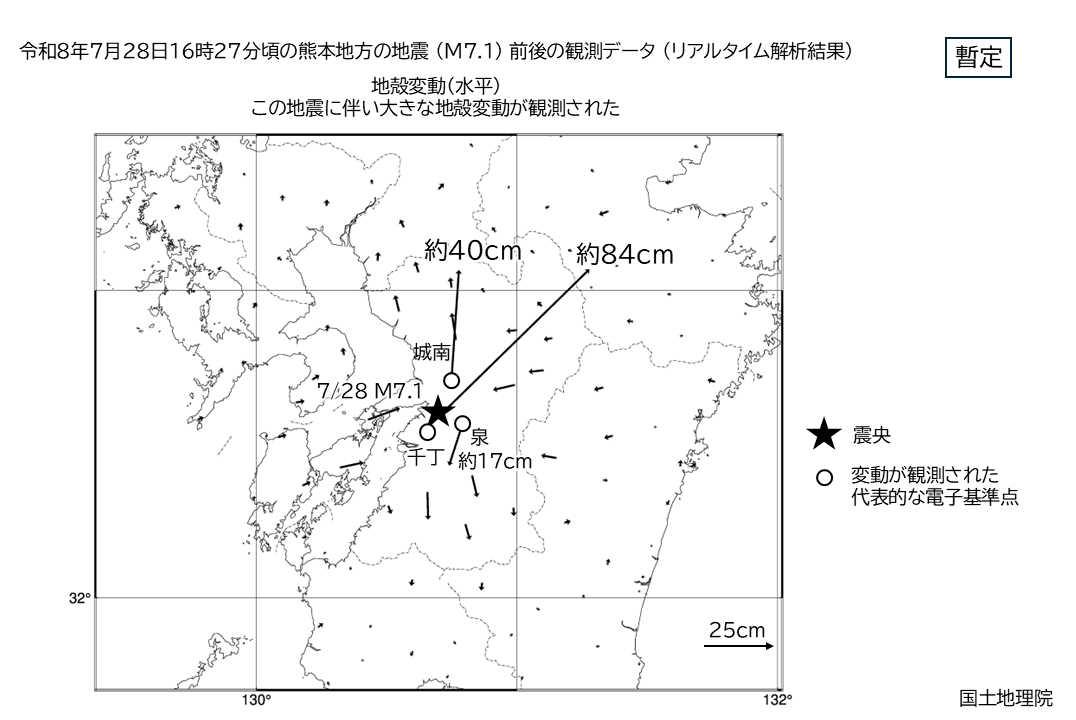
【令和8年8月12日、地震調査委員会の評価】 地震調査委員会は8月12日、令和8年熊本地震に関する2回目の評価を公表しました。震源断層は長さ30〜40km程度の北西傾斜の横ずれ断層と推定され、日奈久断層帯の高野-白旗区間および日奈久区間北東部に対応するとされています。GNSS(衛星測位)観測では、熊本県八代市で北東方向に約87cmの地殻変動が確認されたほか、衛星SAR解析でも広範囲の地殻変動が検出されました。現地調査では、氷川町付近で最大約2mの右横ずれを伴う地表地震断層が確認されています。地震後も、断層のゆっくりとしたすべり(余効変動)が継続しています。
気象庁による本震・前震としての正式な連動性評価は令和8年8月17日時点で示されておらず、今後の公式発表を確認する必要があります。
なお、震源域周辺では断層沿いに地割れが確認されており、「地下水都市」とも呼ばれる熊本市周辺での液状化被害の拡大を懸念する専門家の調査も進められています(詳細は「液状化・地盤沈下の影響」を参照)。
地震発生の瞬間に地表地震断層が出現する様子が、たまたま稼働していた防犯カメラの映像に記録されていたことも判明しました(8月14日報道)。専門家は「極めて貴重で学術的価値が高い」と評価しています。
液状化・地盤沈下の影響
震源域周辺では、地震に伴う地殻変動により液状化や地盤沈下が広範囲で確認されています。
八代市新港町(埋立地・港湾部) では、専門家の現地調査により、大規模な砂の噴出跡(噴砂)、液状化によるとみられる地割れ、地盤の陥没、建物基礎部分の地盤沈下が確認されました。地割れは住宅地・農地を数十kmにわたって横断しており、住宅や擁壁・ブロック塀、橋・道路・護岸などのインフラ、農地に被害を与えています。土地の境界そのものがずれ動いている箇所もあり、そのままでは住宅再建が難しい場合も想定されています。熊本平野の豊富な地下水と、低地・埋立地に多い砂質土という地盤特性が重なり、市街地や産業・物流拠点が集積する沿岸部周辺で液状化が発生しやすい条件がそろっていたとみられます。
八代海沿岸の高潮・浸水リスク:国土交通省は令和8年8月10日、地震に伴う地盤沈下等の地殻変動により、八代海沿岸地域で浸水・冠水の危険が高まっているとして注意を呼びかけました。特に8月13日前後の大潮の満潮時間帯を中心に、潮位が非常に高くなるとされています。気象庁は「令和8年熊本地震」に伴う高潮に関する警報等の暫定的な運用を8月3日から開始しているほか、球磨川(くまがわ)の洪水予報についても暫定基準の運用(8月5日開始)を行っています。国土地理院は八代港に臨時の津波観測装置を設置しました(8月8日)。
産業技術総合研究所は地震発生を受けて「緊急調査対応本部」を設置し、地質調査総合センターのウェブサイトを通じて研究情報を継続的に発信しています。
津波注意報
この地震に伴い、有明・八代海に津波注意報が発表されました(発表:7月28日16時29分/解除:同日18時10分)。首相官邸の会見では、1メートル程度の津波が予想されるとして、海岸に近づかないよう注意が呼びかけられました。
人的被害・避難状況
【最新(総務省消防庁第51報ベース、8月中旬時点)】 死者39人(うち市町村が地震を直接の原因と確認した36人の内訳は、八代市20人、嘉島町7人、氷川町5人、宇城市3人、甲佐町1人。これに災害関連死の可能性がある1人、関連を調査中の2人を加えた合計)。負傷者358人(重傷27人、軽傷等331人)。この内訳は、当初(7月30日時点)の25人からさらに調査が進んだ確定版です。
一方、NHKは8月24日14時時点の熊本県発表として「死者38人」と報じており、消防庁ベースの39人とは1人の差があります。認定区分の見直し等によるものとみられますが、詳細は今後の公式発表で確認する必要があります。
避難者は2,684人(8月24日14時時点、熊本県発表)まで減少しました。避難所は最大時(8月1日前後)に506か所・9,931人を数えましたが、8月12日には83か所・3,646人、8月24日には2,684人へと着実に減少しています。
【勤務中の被災が17人】 厚生労働省は令和8年8月4日、死者38人のうち17人が勤務中に被災して亡くなったことを明らかにしました。イオンモール熊本の爆発と日本製紙八代工場の煙突崩落という2つの事案が、就業中の被災に集中した要因とみられます。
初の災害関連死の疑い
熊本県は令和8年8月2日、地震による避難のため車中泊をしていた70代の女性が、熱中症の疑いで死亡していたことを明らかにしました。女性は7月30日に停車中の車内で発見され、病院に搬送されましたが死亡が確認されました。発見時、車はガソリンが切れてエアコンが停止した状態だったとされています。木村敬(きむらたかし)熊本県知事は、今回の地震で初の災害関連死の疑いがある事例だと説明しています。
平成28年(2016)熊本地震では、犠牲者278人のうち約8割を災害関連死が占めました。木原稔(きはらみのる)官房長官は8月2日、「災害関連死をいかに抑制していくかに軸足を置く」と述べ、車中泊や在宅避難をする人への支援に全力で取り組むよう関係省庁に指示したことを明らかにしています。
死者数の推移(速報値・情報源別)
| 発表時点 | 死者数 | 発表主体 |
|---|---|---|
| 7月29日午前 | 3人(心肺停止5人) | 熊本県災害対策本部 |
| 7月29日10時 | 13人(関連調査中含む) | 高市早苗首相 |
| 7月29日16時台 | 12人(心肺停止6人、負傷64人) | 熊本県災害対策本部 |
| 7月30日12時30分 | 30人(関連調査中含む) | 高市早苗首相 |
| 7月30日15〜16時 | 34人(重症5人、人的被害計120人) | 熊本県災害対策本部(第6回会議) |
| 7月31日19時 | 36人(関連調査中2人) | 熊本県 |
| 8月2日19時 | 38人(関連死疑い1人、調査中2人含む) | 熊本県 |
| 8月3日18時 | 38人(関連死疑いなど含む) | 熊本県 |
| 8月4日14時 | 38人(関連調査中含む) | 熊本県 |
| 8月5日18時 | 38人(関連死疑いなど含む) | 熊本県災害対策本部 |
| 8月7日18時 | 38人 | 熊本県災害対策本部 |
| 8月8日18時 | 39人(新たに1人確認) | 熊本県災害対策本部 |
| 8月15日14時 | 39人(変化なし) | 熊本県 |
| 8月16日8時 | 39人(変化なし) | 熊本県災害対策本部 |
| 8月中旬(第51報) | 39人(内訳確定:八代市20・嘉島町7・氷川町5・宇城市3・甲佐町1=36人+関連死疑い1人+調査中2人) | 総務省消防庁 |
| 8月24日14時 | 38人 | 熊本県(NHK報道) |
7月30日の県発表では、市町村別の内訳として八代市11人、嘉島町(かしままち)7人、氷川町4人、宇城市2人、甲佐町(こうさまち)1人の計25人について、市町村が今回の地震が原因で死亡したと確認しています。
施設別の被害
イオンモール熊本(嘉島町)
令和8年7月28日の本震から約1時間20分後、18時前後に爆発が発生し、建物2階部分が崩落しました(配管からのガス漏れに引火した可能性が専門家により指摘されています)。地震発生時、館内には来店者と従業員合わせて4,000人超がいました。最終的に12人が救助され、7人が死亡、5人がけがをしています。捜索は8月1日正午に終了しました。
館内で被災した従業員のうち2人については、いったん屋外へ避難したのち、店舗の売上金を1階の金庫へ移すよう会社側から指示され、館内に戻った直後に爆発に巻き込まれたことが明らかになっています。雑貨店の運営会社の営業部長は令和8年8月3日、報道陣の取材に対し「後悔しかない」と述べ、遺族に謝罪しました。災害時における従業員の安全確保と企業の責任のあり方をめぐり、議論を呼んでいます。
日本製紙(にっぽんせいし)八代工場(八代市)
八代工場では煙突が倒壊し、9人が死亡しました。今回の地震で最も多くの犠牲者を出した現場となっています。
日本製紙は令和8年8月5日午後3時から八代市内で記者会見を開きました。地震後、同社が会見を開くのは初めてです。瀬辺明(せべあきら)社長は冒頭で「9人の尊い命を失い、極めて重く受け止めている」「亡くなられた方に深く哀悼の意を表す」と述べ、謝罪しました。
会見での説明によると、地震により工場の煙突3本が損傷し、このうち重油ボイラーの煙突(高さ80メートル、昭和45年〈1970〉設置)が中央部分あたりから折れ、2階建ての建物の上に落下しました。この建物でデスクワークをしていた同社社員6人と、協力会社の従業員ら3人の計9人が亡くなっています。煙突が折れたのは地震直後でした。
同社は「倒壊のメカニズムなどは専門家に入っていただいて、調査委員会を立ち上げて検証していきたい」と説明しています。八代工場は事故後も稼働を停止したままで、瀬辺社長は復旧について「本日の時点で具体的な見通しを申し上げるのは難しい」としたうえで、工場の閉鎖は考えていないと述べました。八代工場は主に印刷用紙や新聞用紙を製造しており、敷地面積は約33万平方メートルに及びます。
経済産業省は令和8年8月6日、この煙突倒壊を受けて、自家発電設備を持つ事業者に対し設備の状況について報告を求める通知を出しました。
【要注記】 死者数は情報源・発表時刻によって数字の前後が生じています。総務省消防庁は8月2日8時時点で死者36人、行方不明者11人、重傷95人、軽傷等106人と発表しており、熊本県発表とは数値が異なります。これは各機関の集計対象・タイミングの違いや、関連死の調査進捗によるものとみられます。確定値としては、今後の総務省消防庁・熊本県の公式発表を確認する必要があります。犠牲者の氏名は、AsoPedia の個人情報方針に基づき記載しません。
災害関連死の認定をめぐる課題
熊本日日新聞の8月24日時点の取材によると、災害関連死の認定審査を行う体制について、県内9市町村で審査会の規定が整備されていないことが判明しました。委員に弁護士など法律家を明記していない自治体も10市町にのぼるとされ、審査の遅れが災害弔慰金の支給遅延につながる懸念が指摘されています。日本弁護士連合会(日弁連)は同日、審査会は市町村主体で行うべきとする指針を公表しました。
避難環境の改善に向けた取り組み
災害関連死を防ぐため、熊本県などは避難環境の改善を進めています。令和8年8月3日には、被災者をホテルなどの宿泊施設へ移す「ホテル避難」(2次避難)の受付が始まりました。県内73施設・最大2,200人分が確保され、8月4日時点で289件の申し込みがあったとされています。同日、宇城市と氷川町では応急仮設住宅の建設にも着手しました(宇城市50戸・氷川町20戸、入居目標はそれぞれ9月下旬・9月上旬)。県営住宅29戸の無償提供は8月6日から申込受付が始まります。
避難所ではペット同伴避難の受け入れも進み、被災直後には専門学校がペット同伴可能な避難場所を設置した事例も報じられました。
医療面では、厚生労働省の8月4日時点の集計によると、県内91施設の医療機関から被害報告があり、うち54施設が復旧待ちの状態です。そのうち50施設(宇城市10施設、八代市21施設など)は断水が復旧の妨げとなっており、断水の解消時期がそのまま地域の医療機能の回復時期を規定する状況となっています。高齢者施設では856施設で被害が確認され、断水319施設、停電55施設、ガス停止144施設に上ります。
災害派遣医療チーム(DMAT)は約600人が派遣され、83隊が活動しています。また、熊本県・福岡県・宮崎県の薬剤師会によるモバイルファーマシー(移動薬局)3台が、宇城市・八代市・氷川町で稼働しています。処方箋への対応に加え、避難所での熱中症・静脈血栓塞栓症(エコノミークラス症候群)の予防啓発、二酸化炭素濃度の測定、室温30度以下の維持といった環境管理も担っています。
避難所での感染症発生
避難生活の長期化に伴い、感染症の課題も生じています。8月4日以降、八代市・宇城市の複数の避難所で発熱や呼吸器症状のある人が確認され、新型コロナウイルス感染症の患者も発生しました。8月12日時点で八代市9人、宇城市8人と報告されています。厚生労働省は災害時感染制御支援チーム(DICT)および実地疫学専門家(FETP)を派遣し、避難所の巡回・アセスメントを行っています。
猛暑と熱中症への警戒
被災地では地震発生後、連日の猛暑が続いています。熊本市では令和8年8月3日に40.3度を記録し、県内観測史上最高かつ県内初の「酷暑日(こくしょび)」となりました(酷暑日は最高気温40度以上を指す用語で、気象庁が令和8年〈2026〉に新設しました)。県内18地点のうち10地点で観測史上最高を更新し、宇城市39.2度、八代市39.0度を観測しています。同日午後4時までに熱中症の疑いで43人が救急搬送され、うち4人が重症でした(速報値)。熊本県内の熱中症による救急搬送者数は前週比1.4倍に増加しており、避難者の厳しい環境での生活が影響したとみられています。
気象庁は8月4日、8月11日にかけて最高気温が35度前後となる日が多く、最低気温も30度前後の熱帯夜が続く見込みであるとし、昼夜を問わず熱中症などの健康管理に注意するよう呼びかけました。8月6日以降は台風13号の影響で曇りや雨の日が多くなる見通しです。
夜間も気温が下がらない状態が続いており、熊本市の8月8日朝の最低気温は30度と予想されました。気象庁・NHKは、昼夜を問わず熱中症対策を徹底するよう繰り返し呼びかけています。8月9日も熊本県内は厳しい暑さが続く見込みで、復旧作業に当たる関係者への熱中症への注意も呼びかけられています。
断水が続く中での熱中症リスク、車中泊避難者の体調悪化が深刻な課題となっており、上述の災害関連死の疑い事例もこの猛暑下で発生しました。政府は熱中症対策として、水や食料品のほか段ボールベッド・スポットクーラーなどを避難所へ届ける「プッシュ型支援」を進めています。
災害ボランティアの活動も本格化しており、令和8年8月8日からは氷川町でもボランティアの受け入れが始まりました。
建物・インフラ被害
- 熊本城(熊本市):熊本城総合事務所によると、石垣の崩落が28か所で確認されたほか、監物櫓(けんもつやぐら)など4つの建造物で壁面のひび割れ等の被害が確認されました。熊本城は平成28年(2016)熊本地震で被災し、天守閣は復旧したものの、石垣を含む城全体の完全復旧は令和34年度(2052年度)を見込んでいました。今回の被災により、復旧がさらに長期化する懸念が指摘されています。なお、周辺の公園部分は安全確認を経て8月13日に再開園しています。
- 住宅被害:総務省消防庁第51報(8月中旬時点)によると、全壊1,274棟、半壊1,046棟、一部破損9,476棟の計11,796棟でした。その後も被害調査が進み、8月18日時点では3万2,000棟を超えたと報じられています。当初(8月2日午前7時30分時点)は3,851棟(うち全壊181棟)でしたが、調査対象地域の拡大に伴い段階的に大きく増加しました。震度7を観測した氷川町では、7月30日時点で125棟の家屋が全壊し、800棟以上で被害が確認されていました。熊本県では、住宅の被害拡大を防ぐための緊急修理(ブルーシート展張等)制度も案内されています。
- 応急危険度判定の完了:二次災害防止のための被災建造物の応急危険度判定調査は、8月13日に県内で終了し、対象9,553件の判定が完了しました。
- 仮設住宅:令和8年8月3日、宇城市と氷川町で建設型仮設住宅の着工が始まりました。甲佐町でも建設型仮設住宅の入居申込みが8月26日から9月11日まで受け付けられています。
- 断水:発災直後は熊本県内17市町村の約14万戸で断水し、一時は4県15自治体・約10万8,100戸に達しました(消防庁ベースでは最大約10万8,000戸)。市町村別の最大戸数は八代市約25,269戸、熊本市約20,970戸、宇城市約18,000戸、人吉市約15,000戸、宇土市約12,200戸、上天草市約7,670戸、氷川町約3,231戸でした。熊本市・人吉市・宇土市・上天草市は8月1〜3日までに解消しましたが、震度7を観測した宇城市・氷川町と震度6強の八代市では長期化し、8月14〜15日時点でも約2万7,000〜2万8,000戸(八代市約21,584戸、宇城市4,098戸、氷川町1,704戸)で断水が続いています。国土交通省は8月末の断水解消を目標としていますが、これは水道本管まで通水可能になる段階を指し、各家庭の蛇口から使えるようになるまでにはさらに時間がかかる見込みです。 断水が長期化した主な原因は、水道管の破損に伴う漏水です。漏水箇所の特定には試験通水を繰り返す必要があり、その間は住民に水の使用自粛が要請される期間も生じました。 応急給水には給水車が投入され、最大時で147台(国土交通省18台、日本水道協会120台、自衛隊9台)に達しました。海上保安庁の巡視船や国土交通省の船舶による給水・入浴支援、水資源機構の可搬式浄水装置(氷川町で稼働)も行われています。8月11日には、井戸を利用する家庭・施設向けの「井戸水対応チーム」が新設されました。八代市では地震の影響で井戸水が出なくなった被害が約4,400戸で確認されています(8月18日時点)。 なお、国土交通省の令和6年度末調査によると、災害拠点病院や避難所など重要施設に接続する水道管の耐震化率は全国で32%であるのに対し、震度7を観測した宇城市は4%、八代市は29%、上天草市は6%にとどまっていました。水道インフラの耐震化の遅れが断水の長期化につながったと指摘されています。
- 停電:最大約4万8,530戸が停電しましたが、令和8年8月1日に全面解消しました。
- 都市ガス:日本ガス協会によると、八代市の約8,900〜9,000戸で都市ガス供給が停止しました。他のガス事業者から約650人規模の応援を受けて復旧作業が進められ、8月12日時点でも1,300戸あまりが供給停止のままでした。
- 農業への影響:断水・水利施設の被害により、水田が干上がる被害も発生しました。ポンプによる農業用水の緊急供給が行われています(8月18日時点)。
- 仮設住宅の設置:氷川町では8月1日から、空気で膨らませて内側に断熱材を吹き付ける簡易住宅「インスタントハウス」の設置が始まりました。約2時間で1棟が完成し、避難者のプライバシー確保につながるとされています。
- 医療機関・学校:令和8年8月3日時点で、県内の医療機関や学校においても建物被害が確認されています。
- 災害廃棄物:県内12市町村が災害ごみの仮置き場を設置しています。震度7を観測した氷川町では8月3日から竜北グラウンド駐車場で受け入れが始まり、八代市でも仮置き場が設置されました。宇土市は8月8日から受け入れを開始します。熊本市では災害ごみの特別収集を実施しており、大型ごみや家電4品目を無料で回収しています。仮置き場には長い車列ができ、多いときには100台以上が並ぶ状況が報じられています。
- 罹災証明書:住宅被害の程度を市町村が認定する罹災証明書は、支援金・応急修理・仮設住宅・公費解体などの公的支援を受けるための入口となります。熊本市・宇城市・宇土市・益城町・八代市などで申請受付が行われており、デジタル庁はオンライン申請にも対応していることを紹介しています。
- 経済活動への影響:東京エレクトロン九州は、稼働を停止していた合志市・大津町の事業所について、8月3日からの操業再開を発表しています。イオングループの一部店舗(ゆめマート等)も順次営業を再開しています。 半導体関連では、ソニーセミコンダクタソリューションズの錦(にしき)工場(菊陽町)が7月31日朝に震災前の生産能力に復帰しました。同社川尻(かわしり)工場(熊本市)は当初8月5日からの順次生産再開を予定していましたが、8月4日に前倒しで再開し、再開から約3週間をめどに震災前の生産能力への復帰を目指すとしています。 自動車関連では、ホンダの二輪車生産拠点である熊本製作所(大津町)に加え、供給網への影響を受けた埼玉・三重の工場でも生産が停止し、8月19日まで一部を除き稼働を止めることが発表されました。トヨタ自動車は福岡県内の3工場を一時再停止していましたが、供給網の遅れを受けて愛知県の田原工場でも稼働に影響が出ていました。田原工場は8月17日に稼働を再開しています。 熊本県商工会連合会が8月24日に公表した調査によると、震度7を観測した宇城市・八代市・氷川町以外の地域でも、事業者の約6割が何らかの被害を受けたと回答しており、地震の経済的影響は震源近傍にとどまらず県内広域に及んでいることが明らかになっています。地元金融機関の肥後銀行は、休業していた八代市田中町支店を8月24日に再開しました。小売大手のイズミは熊本県に1億円を寄付しています(8月14日)。
交通機関への影響
- JR九州は、地震直後に管内の全線区で列車の運行を一時見合わせました。西九州新幹線は同日19時頃に運転を再開しましたが、九州新幹線は全線で運転を取りやめました。走行中に停止した列車のうち1本は新八代-新水俣間で長時間停車し、乗客約180人が一時取り残されました。
- 九州新幹線:博多-筑後船小屋間は7月29日夕方に再開(減便)。筑後船小屋-熊本間は7月31日始発から運転を再開しました(1時間に1〜2本程度、全列車各駅停車、山陽新幹線との相互直通運転なし)。新水俣-鹿児島中央間は8月7日に運行を再開しました(1日6往復のダイヤ)。残る熊本-新水俣間は8月中の運転再開が困難な状況です。断層の直下にあたる区間ではレールの破断やゆがみが生じており、被害が集中したと報じられています。
- 鹿児島本線:荒尾-熊本間は7月30日に運転を再開。熊本-宇土間は8月2日から当面の間、減便で運転しています。宇土-八代間は当面の間、終日運転見合わせが続いており、8月中の運転再開を見込むとされています。川内-隈之城間は8月5日から通常運転の予定です。
- 豊肥本線(ほうひほんせん)(阿蘇を経由する区間):宮地(みやじ)-豊後竹田間は7月29日に、熊本-肥後大津間は7月30日にそれぞれ運転を再開しました。令和8年8月2日9時時点のJR九州の運行情報では、豊肥本線は運転見合わせ・減便のいずれの対象区間にも含まれておらず、全線で通常運転に復帰しています。
- 三角線:宇土-三角間は8月2日から運行を再開しました。
- 南阿蘇鉄道(みなみあそてつどう):7月30日に運行を再開しました。
- 熊本市電・熊本電気鉄道:7月29日は速度を落とした状態で運転を再開しましたが、7月30日には平常運行に復帰しています。
- 阿蘇くまもと空港:通常運行が継続されています。
- 肥薩(ひさつ)おれんじ鉄道:八代-水俣間で代行バスの運行が8月10日から開始されました。水俣-川内(せんだい)間は8月5日始発から運転を再開しています。これにより、新水俣で九州新幹線(8月7日再開)と接続し、水俣-鹿児島県内が鉄道で結ばれる形になりました。
- 高速バス:熊本-阿蘇山上・草千里線(阿蘇山上線)は8月中の全便運休が決定しています。福岡-宮崎線「フェニックス号」は8月7日から大分自動車道・東九州自動車道経由での迂回運行としていましたが、8月17日から通常ルートでの運行を再開(一部運休)しました。熊本-宮崎線「なんぷう号」も同様に8月17日から通常ルートに戻っています。新八代-宮崎線「B&Sみやざき」は8月中の全便運休が決定、熊本-黒川・湯布院・別府線「九州横断バス」は8月中1往復のみの運行が続いています。
- 高速道路:8月1日時点で高速道路9区間が通行止めとなっていましたが、8月14日、九州自動車道は全線で一般車両の通行が可能になりました。それまで通行止めが続いていた松橋(まつばせ)インターチェンジ-えびのインターチェンジ間を含め、県内の主要高速道路網は震災から2週間あまりでほぼ復旧しています。
阿蘇地域への影響
阿蘇地域は震源地の熊本地方から見て北東側に位置し、今回の地震では阿蘇市・南阿蘇村・高森町で震度5弱、西原村で震度6弱を観測しました。震源に近い宇城市・氷川町・八代市周辺と比較すると震度は低いものの、以下の影響が確認されています。
- JR豊肥本線:阿蘇市内を含む宮地-豊後竹田間は7月29日に、熊本-肥後大津間は7月30日にそれぞれ運転を再開しました。令和8年8月2日9時時点のJR九州の運行情報では、豊肥本線は運転見合わせ・減便のいずれの対象にも含まれておらず、全線で通常運転に復帰しています。平成28年(2016)熊本地震では肥後大津-阿蘇間が4年4か月にわたり不通となり、令和2年(2020)8月8日にようやく全線復旧した経緯があります。
- 南阿蘇鉄道:7月30日に運行を再開しました。平成28年(2016)熊本地震では全線復旧までに7年を要しましたが、今回は発災3日目での再開となっています。
- 高速バス:熊本-阿蘇山上・草千里線(阿蘇山上線)は8月中の全便運休が決定しており、阿蘇地域への観光アクセスに継続的な影響が出ています。
- 道路:通行止めが続く九州自動車道の松橋インターチェンジ-えびのインターチェンジ間は震源に近い県南部の区間であり、阿蘇地域を通るミルクロード・国道57号などの主要道路への被害報告は令和8年8月17日時点で確認できていません。
- 阿蘇くまもと空港:通常運行が続いており、県外からの阿蘇地域へのアクセスは維持されています。
- 国土地理院の解析によれば、今回活動した日奈久断層帯の破壊域(日奈久区間北東側)は熊本地方南部から八代方面にかけてであり、阿蘇地域の直下には及んでいないとみられます。ただし、これは断層モデル解析に基づく推定であり、阿蘇地域内の個別施設の被害有無を直接示すものではありません。
- 平成28年(2016)熊本地震で甚大な被害を受け、令和7年(2025)2月に災害復旧事業を終えた阿蘇神社(あそじんじゃ)や、令和3年(2021)3月に新阿蘇大橋として復旧した阿蘇大橋(あそおおはし)など、復興を経た施設・インフラへの今回の地震による被害報告は、令和8年8月17日時点で確認できていません。
政府・自治体の対応
首相官邸は令和8年7月28日、高市早苗(たかいちさなえ)総理大臣が地震発生を受けて会見し、関係省庁に被害状況の早急な把握、地方自治体との緊密な連携、人命第一での災害応急対策、津波・避難情報の適時適確な提供を指示したことを明らかにしました。同日19時56分、令和8年熊本地震非常災害対策本部の第1回会合が開かれ、以後も継続的に会合が開催されています。
政府は7月30日、熊本県庁内に現地対策本部を設置しました。7月31日の非常災害対策本部会議では、被災自治体への支援として総額616億円の普通交付税を繰り上げ交付することが説明され、高市首相は「今後も必要な予算の手当は行うので、各自治体は財政的にちゅうちょすることなく、全力で応急、復旧対応に当たってほしい」と述べています。
首相の被災地視察と激甚災害指定
高市首相は令和8年8月3日、被災地を訪問しました。発災後、首相が現地入りするのは初めてです。首相はまず益城町・嘉島町・御船町・熊本市・宇城市・氷川町・八代市・宇土市の上空から、道路・橋・港などの公共インフラ被害や企業の被害状況をヘリコプターで確認しました。その後、氷川町の避難所となっている氷川中学校を訪れ、避難者から避難生活の状況や若い世代の暮らしへの不安について直接聞き取りを行い、「できることは全てやるつもりです」と述べました。避難者からは、子育て世代への支援やペット同伴が可能な避難所の拡大を求める声が上がりました。
同日、熊本県防災センターで木村敬知事と意見交換したのち、首相は記者団に対し、今回の地震で被害を受けた公共土木施設や農地などの復旧について「激甚災害(本激)」に指定する方針を明らかにしました。本激は地域を特定せず災害そのものを対象とする指定で、災害復旧事業に対する国の補助率が引き上げられ、自治体の財政負担が軽減されます。あわせて、運転免許証の有効期間延長など行政手続きの特例を適用できる「特定非常災害」への指定も決定しました。
首相は良好な生活環境の確保、水道などインフラ設備の迅速な復旧、医療や福祉分野の支援強化を強調し、「自治体や関係団体と連携して、先手で取り組みを進める」と述べています。
予備費242億円の支出決定
政府は令和8年8月4日の閣議で、復旧・復興の支援として令和8年度予算の予備費から総額242億円を支出することを決定しました。内訳は、水や食料品・段ボールベッド・スポットクーラーなどのプッシュ型物資支援に24億円、都道府県などが行う応急仮設住宅の提供といった救助業務への支援に12億円、災害復旧に206億円です。
同日開かれた非常災害対策本部会議で、高市首相は「予算の制約により災害対応をためらうことがあってはならない」との考えのもと、応急対応から本格復旧・復興に至るまで被災地の状況に応じて躊躇なく予備費を活用していく方針を示しました。
激甚災害への正式指定(8月7日)
政府は令和8年8月7日、持ち回り閣議で「令和8年熊本地震による災害についての激甚災害及びこれに対し適用すべき措置の指定に関する政令」を決定し、今回の地震を激甚災害に正式に指定しました。被害の規模が大きいため、地域を限定しない「本激」となっています。同日、あわせて「特定非常災害」の指定に関する政令、および総合法律支援法に基づく指定に関する政令も決定されました。
激甚災害法(激甚災害に対処するための特別の財政援助等に関する法律)に基づき、公共土木施設(漁港等を含む)の災害復旧事業等について、国庫補助率が嵩上げされます。農林水産省の説明によると、過去5か年の実績の平均では、公共土木施設等の補助率は71%から84%に引き上げられます。農地等の災害復旧事業についても特別の財政措置が適用されます。
なお、発災当日の7月28日には、熊本県内10市10町1村(計21市町村)に災害救助法が適用されています。また、被災者の住宅再建を支援する被災者生活再建支援法も、令和8年8月10日に適用されました。
台風13号への警戒
大型で非常に強い台風13号(ドルフィン)は、令和8年8月7日から8日にかけて沖縄・奄美地方に接近し、動きが遅かったため風雨の影響が長時間続きました。8月9日3時時点では宮古島の北北西海上を西北西へ進んでおり、その後は東シナ海を経て華中方面へ向かう見込みです。
結果として、台風13号による熊本県内での大きな二次災害は確認されませんでした。 熊本県では強風や乾燥注意報の発表はあったものの、沖縄・奄美地方と比べて影響は限定的でした。台風接近前には、気象庁が被災地の一部で大雨警報・注意報の発表基準(土壌雨量指数基準)を引き下げる暫定運用を実施し、屋根の応急処置と熱中症リスクが両立する状況への注意が呼びかけられていました。
なお、震度5強以上を観測した市町村では、地震で地盤が緩んでいることに変わりはなく、今後も降雨時には土砂災害への注意が必要な状態が続いています。
よくある質問
Q. 令和8年熊本地震はいつ、どこで発生しましたか? A. 令和8年(2026)7月28日16時27分頃、熊本県熊本地方を震源として発生しました。マグニチュードは7.1(暫定値)です。
Q. 最大震度はどこで観測されましたか? A. 熊本県宇城市と氷川町で最大震度7を観測しました。阿蘇市・南阿蘇村・高森町では震度5弱でした。
Q. 死者はどれくらいですか? A. 総務省消防庁の集計(第51報、8月中旬時点)では39人です(市町村が地震原因と確認した36人=八代市20・嘉島町7・氷川町5・宇城市3・甲佐町1、プラス関連死疑い1人・調査中2人)。ただしNHKは8月24日時点の熊本県発表として「38人」と報じており、1人の差があります。負傷者は358人(重傷27人、軽傷等331人)です。このうち17人は勤務中に被災して亡くなったことが厚生労働省により明らかにされています。数字は情報源・発表時刻により前後があるため、最新の公式発表の確認が必要です。
Q. 避難者はどれくらい減りましたか? A. 避難所はピーク時(8月1日前後)に506か所・9,931人でしたが、8月12日には83か所・3,646人、8月24日には2,684人まで減少しています。断水の解消、仮設住宅の整備、ホテル等への二次避難の進展が要因とみられます。
Q. 住宅被害はどれくらいですか? A. 総務省消防庁の集計(8月中旬時点)では全壊1,274棟・半壊1,046棟・一部破損9,476棟の計11,796棟でしたが、被害調査の進展に伴い8月18日時点では3万2,000棟を超えたと報じられています。数値は今後さらに変動する可能性があります。
Q. 最も犠牲者が多かった場所はどこですか? A. 八代市の日本製紙八代工場です。重油ボイラーの煙突(高さ80メートル)が折れて2階建ての建物に落下し、9人が亡くなりました。次いで嘉島町のイオンモール熊本での爆発により7人が亡くなっています。
Q. 激甚災害に指定されましたか? A. はい。政府は令和8年8月7日の持ち回り閣議で、今回の地震を激甚災害(本激)に正式指定しました。公共土木施設等の国庫補助率が嵩上げされます(過去5か年実績の平均で71%→84%)。あわせて「特定非常災害」の指定も決定しています。復旧・復興予算としては、8月4日の閣議で予備費から総額242億円の支出が決定されました。
Q. 台風13号の被害はありましたか? A. 台風13号(ドルフィン)は8月7日から8日にかけて沖縄・奄美地方に接近しましたが、熊本県への直接的な影響は限定的で、大きな二次災害は確認されませんでした。ただし、地震で地盤が緩んだ地域では、今後も降雨時の土砂災害に注意が必要な状態が続いています。
Q. 断水はいつ解消される見込みですか? A. 8月14〜15日時点でも八代市・宇城市・氷川町を中心に約2万7,000〜2万8,000戸で断水が続いています。国土交通省は8月末までの解消を目標としていますが、これは水道本管への通水段階を指し、各家庭で使えるようになるまではさらに時間がかかる見込みです。原因は水道管の破損に伴う漏水で、井戸水にも被害が出ています(八代市で約4,400戸、8月18日時点)。
Q. 災害関連死は発生していますか? A. 令和8年8月2日、車中泊避難をしていた70代女性が熱中症の疑いで死亡していたことが公表され、今回の地震で初の災害関連死の疑いがある事例とされています。平成28年熊本地震では犠牲者の約8割が災害関連死でした。
Q. 平成28年(2016)の熊本地震と関係がありますか? A. 国土地理院の解析(令和8年7月29日発表)により、2016年の地震で活動しなかった日奈久断層帯の一部区間(日奈久区間北東側)が今回動いたことが確認されています。ただし、気象庁による本震・前震としての正式な関連性評価は令和8年8月17日時点でまだ示されていません。
Q. 今後さらに大きな地震が起きる可能性はありますか? A. 専門家は、日奈久断層帯の南西側30〜40km区間(八代海区間を含む)が未活動の「割れ残り」状態にあると指摘しており、いわゆる「半割れ」の状態としてさらなる大規模地震への注意を呼びかけています。8月4日15時までに震度1以上の地震が521回発生しており、地震活動は依然として活発な状態です。気象庁は8月4日の会見で、今後1週間程度、最大震度5強程度以上の地震に注意するよう呼びかけています。
Q. 阿蘇地域への影響はありますか? A. 震度は震源付近と比べて小さく、阿蘇市・南阿蘇村・高森町で震度5弱でした。交通面では一時的に影響が出ましたが、南阿蘇鉄道は7月30日に運行を再開し、JR豊肥本線も8月2日時点で全線が通常運転に復帰しています。阿蘇神社・新阿蘇大橋など2016年被災施設への今回の被害報告は、8月17日時点で確認されていません。
関連項目
参考文献
- 気象庁「令和8年7月28日16時27分頃の熊本県熊本地方の地震について(第2報)」(2026年7月28日)
- 気象庁「令和8年熊本地震の地震活動の関連情報」
- 気象庁「令和8年熊本地震 ポータルサイト」 https://www.jma.go.jp/jma/menu/20260728_kumamoto_jishin.html
- 気象庁「『令和8年熊本地震』について(第3報)」(2026年7月28日) https://www.jma.go.jp/jma/press/2607/28d/202607282030.html
- 国土交通省「令和8年熊本地震による被害状況等について」(第1報〜第23報、2026年7月28日〜8月3日16時30分時点) https://www.mlit.go.jp/saigai/saigai_260728.html
- 国土地理院「令和8年(2026年)熊本地震に関する情報」(2026年7月28日公表、7月30日更新) https://www.gsi.go.jp/BOUSAI/20260728_kumamoto_earthquake.html
- 厚生労働省「令和8年熊本地震について」(第1報〜第28報) https://www.mhlw.go.jp/stf/newpage_75017.html
- 首相官邸「令和8年熊本地震について」(2026年7月28日)/「令和8年熊本地震についての会見(2)」(2026年7月29日) https://www.kantei.go.jp/jp/105/statement/2026/0729kaiken.html
- 首相官邸「令和8年熊本地震による被災状況視察のための熊本県訪問についての会見」(2026年8月3日) https://www.kantei.go.jp/jp/105/statement/2026/0803kaiken.html
- NHKニュース「令和8年熊本地震」特設ページ(2026年7月28日〜8月3日各報)、「熊本城 石垣の崩落 28か所で確認」(7月29日)、「【被害状況】熊本地震 関連調査中含め36人死亡 熊本県発表」(7月31日)、「熊本地震 車中泊で死亡 熱中症疑い 3日 熊本 酷暑日予想で注意」(8月2日)、「高市首相 あす熊本地震の被災地訪問へ 政府発表」(8月2日)
- FNNプライムオンライン/テレビ熊本「令和8年熊本地震の死者38人に 避難者9226人 3日は最高気温40度の酷暑日となる見込み」(2026年8月2日)
- 日本経済新聞「熊本地震の死者38人に 初の災害関連死疑い、車中泊で熱中症か」(2026年8月2日)、「高市早苗首相、3日に熊本地震の被災地視察へ 発災後初の現地入り」(2026年8月2日)
- 熊本日日新聞「<2026年熊本地震>高市首相、激甚災害指定へ 復旧復興予算『予備費から200億円超』支出」(2026年8月3日21時56分) https://kumanichi.com/articles/2021471
- 日本経済新聞「熊本地震、首相が激甚指定を表明 予備費200億円超使用も決定へ」(2026年8月3日)、「爆発前、従業員に館内戻るよう指示 イオンモール熊本のテナント会社」(2026年8月2日)
- 時事ドットコム「高市首相、3日に熊本視察 復旧・復興に全力」(2026年7月31日)、「避難後、戻るように指示 イオン爆発で従業員2人死亡―所属会社が謝罪・熊本地震」(2026年8月3日)
- FNNプライムオンライン「熊本地震発生から1週間 危険な暑さ続く 死者38人、8262人避難、住宅被害1万2276棟」(2026年8月4日6時30分)
- NHKニュース「熊本地震1週間 周辺に動いていない活断層も 備えを」(2026年8月4日)、「地震の死亡38人 医療機関や学校の被害も(8月3日時点)」(2026年8月3日)、「熊本市などで初の酷暑日 被災地で4日も危険な暑さ続く見込み」(2026年8月3日)
- 日本気象協会tenki.jp「熊本県で震度5弱の地震 津波の心配なし」(2026年8月1日)
- 首相官邸「令和8年熊本地震非常災害対策本部会議」(2026年8月4日) https://www.kantei.go.jp/jp/105/actions/202608/04hijoukaigi.html
- 日テレNEWS NNN「【速報】令和8年熊本地震 政府が予備費から総額242億円の支出決定 『激甚災害』に指定の方針」(2026年8月4日)
- 共同通信「熊本、1週間は震度5強以上注意 気象庁『活動は依然活発』」(2026年8月4日)
- 時事ドットコム「熊本地震、なお7500人超避難 酷暑の被災地、住宅被害1.3万棟―断水は月内解消見込み・発生1週間」(2026年8月4日)
- 日本経済新聞「熊本地震1週間、断水4万戸超 住まい再建見えず『それでも前へ』」(2026年8月4日)、「熊本の断水7万戸、災害拠点つなぐ水道耐震化遅れ 震度7の宇城4%」(2026年7月31日)
- 毎日新聞「熊本地震から1週間 なお続く断水、猛暑 7500人が避難生活」(2026年8月4日)
- 熊本ニュースKAB「震度1以上が520回超える『1週間程度は最大震度5強程度以上の地震に注意』気象庁」(2026年8月4日)
- 熊本日日新聞「<2026年熊本地震>7万2千戸、断水続く 避難者9228人 熊本県発表」(2026年8月1日)
- 熊本県「令和8年熊本地震に関する情報」 https://www.pref.kumamoto.jp/soshiki/1/274517.html
- 首相官邸「令和8年熊本地震について」(最終更新:令和8年8月4日) https://www.kantei.go.jp/jp/kikikanri/earthquake20260728.html
- 朝日新聞「日本製紙が会見『深くおわび』熊本地震で9人犠牲、煙突3本が損傷」(2026年8月5日)
- 日本経済新聞「日本製紙社長、熊本工場『復旧見通せず』 煙突倒壊事故で謝罪」(2026年8月5日)、「日本製紙、熊本被災の八代工場『閉鎖考えていない』 業績予想未定に」(2026年8月5日)
- NHKニュース「熊本地震で9人死亡の日本製紙 初めて記者会見 社長が陳謝」(2026年8月5日)、「経産省 日本製紙の煙突倒壊受け自家発事業者に報告求める通知」(2026年8月6日)、「熊本地震 7日にも『激甚災害』指定を閣議決定へ調整 政府」(2026年8月6日)、「大型で強い台風13号 沖縄・奄美に接近へ 厳重警戒を」(2026年8月6日)
- 共同通信「熊本地震の激甚災害指定、7日にも閣議決定」(2026年8月4日)
- 読売新聞オンライン「『言葉にならんばい』煙突が折れた日本製紙八代工場内にいた男性は…熊本地震ルポ」(2026年8月6日)
- RCC中国放送「【台風情報】『大型』『非常に強い』台風13号 進路・『各国モデル』比較 最大瞬間風速60m/s 7日頃に沖縄直撃か その後北に進み熊本地震被災地への影響懸念 気象庁」(2026年8月5日)
- 日本気象協会tenki.jp「台風13号 7日から沖縄を直撃 動き遅く影響が長引く 九州南部も雨量多くなる恐れ」(2026年8月5日)、「【速報】台風13号 沖縄本島の一部が暴風域に入りました」(2026年8月7日)
- 沖縄タイムス「【台風13号】沖縄本島の路線バス、7日は終日運休」「【台風13号】美ら海水族館など7日は休業 イベント中止・延期も相次ぐ」(2026年8月6日)
- 首相官邸「令和8年8月7日(金)持ち回り閣議案件」(2026年8月7日) https://www.kantei.go.jp/jp/kakugi/2026/kakugi-2026080701.html
- 農林水産省「令和8年熊本地震による災害についての激甚災害及びこれに対し適用すべき措置の指定に関する政令について」(2026年8月7日) https://www.maff.go.jp/j/press/kanbo/bunsyo/saigai/260807_1.html
- 共同通信「熊本地震を激甚災害に指定 政府」(2026年8月7日)
- NHKニュース「熊本地震の被害を『激甚災害』に指定 自治体の復旧費用支援へ」(2026年8月7日)、「九州新幹線 新水俣~鹿児島中央で運行再開 1日6往復のダイヤ」(2026年8月7日)、「熊本地震 死者1人増える 災害関連死の疑い1人含め 死者39人に」(2026年8月8日)、「地震被害の熊本 夜間も気温下がらず 熱中症対策徹底 揺れにも備えを」(2026年8月7日)、「熊本地震 災害関連死の疑い含め38人死亡 避難所に6630人避難」(2026年8月7日)、「熊本地震 災害ボランティアの活動が本格化 8日から氷川町でも」(2026年8月8日)
- 日本気象協会tenki.jp「台風13号(2026年) 最新位置・進路予想」(2026年8月9日3時時点) https://tenki.jp/bousai/typhoon/2613/
- 熊本市「【報道資料】熊本市災害対策本部会議資料」(2026年8月8日) https://www.city.kumamoto.jp/kiji00372080/
- 気象庁「令和8年熊本地震 ポータルサイト」(最終更新:2026年8月12日) https://www.jma.go.jp/jma/menu/20260728_kumamoto_jishin.html
- 地震調査研究推進本部「令和8年熊本地震の評価」(2026年7月29日公表・2026年8月12日公表) https://www.jishin.go.jp/main/oshirase/20260728_kumamoto.html
- テック・アイ技術情報研究所「令和8年熊本地震の評価」(2026年8月13日、8月12日評価の要約) https://tiisys.com/blog/2026/08/13/post-200522/
- 産業技術総合研究所地質調査総合センター「令和8年(2026年)熊本地震の関連情報」(2026年7月30日開設、8月13日更新) https://www.gsj.jp/hazards/earthquake/kumamoto2026/index.html
- 桜井鑑定事務所「令和8年熊本地震・緊急現地調査からの提言」(2026年8月、液状化・地割れに関する現地調査) https://www.sakurajimusyo.com/opinion/disaster/2725/
- 国土交通省「熊本地震に伴い八代海沿岸地域では浸水や冠水にご注意ください〜8月13日前後の満潮時間帯を中心に潮位が非常に高くなります〜」(2026年8月10日報道発表) https://www.mlit.go.jp/report/press/port07_hh_000269.html
- NHKニュース「熊本地震 災害関連死の疑い含め39人死亡 避難所に3121人避難」(2026年8月16日)、「熊本地震 地震活動と暑さに注意 できるかぎりの熱中症対策を」(2026年8月17日)、「熊本地震 17日も熱中症対策を 最大震度5弱程度以上の地震注意」(2026年8月16日)、「熊本地震影響 トヨタ田原工場で再開 ホンダは停止続く」(2026年8月17日)、「熊本地震 『くまモン』が活動再開 被害受けた小学校を訪問」(2026年8月16日)、「九州新幹線 新水俣~鹿児島中央で運行再開 1日6往復のダイヤ」(2026年8月7日)
- CAR CARE PLUS「熊本地震1週間、TSMCなど半導体工場復旧、ホンダ国内3工場は8月19日まで停止」(2026年8月6日)
- EE Times Japan「令和8年熊本地震、半導体メーカー工場の対応状況」(2026年8月4日19時10分更新)
- 日刊工業新聞「令和8年熊本地震 トヨタ・ホンダ稼働停止 半導体は安全確認急ぐ」(2026年7月29日)
- Yahoo!ニュース/KBC九州朝日放送「九州新幹線 新水俣=鹿児島中央間が8月7日に運行再開 熊本=新水俣間は8月中は再開困難」(2026年8月5日)
- レイルラボニュース「九州新幹線、新水俣〜鹿児島中央が8月7日運転再開 熊本〜新水俣は復旧作業続く」(2026年8月)
- Wikipedia「熊本地震(2026年)」(高速バス各路線の運行状況、8月17日時点)
- 産業医科大学産業生態科学研究所 災害産業保健センター「【定点観測】令和8年熊本地震 8月5日7時時点 — 産業保健のための状況整理」(2026年8月5日) https://dohcuoeh.com/r8kumamoto260805/
- NHKニュース「熊本地震 災害関連死の疑い含め38人死亡 避難所に7122人が避難」(2026年8月5日)、「九州新幹線 新水俣~鹿児島中央 7日から運行再開」(2026年8月5日)、「熊本 氷川町で災害廃棄物の受け入れ開始 八代で仮置き場を設置」(2026年8月3日)
- 日本経済新聞「九州新幹線の新水俣―鹿児島中央間、7日に運行再開 JR九州」(2026年8月5日)
- 熊本日日新聞「<2026年熊本地震>新水俣-鹿児島中央 7日に再開 九州新幹線」(2026年8月5日)、「熊本地震、九州の『大動脈』に深い傷痕 新幹線レールに破断、ゆがみ…断層直下で被害集中」(2026年8月)
- 熊本ニュースKAB「2026年熊本地震の『災害ごみ』12市町村が仮置き場を設置へ」(2026年8月)
- khb東日本放送「熊本地震 県内54の医療機関で断水など被災続く 勤務中の死者は17人 厚労省」(2026年8月4日)
- 時事ドットコム「ペット同伴避難、飼い主安心 被災直後、専門学校が設置―熊本地震」(2026年8月5日)、「台風接近、熊本に警戒呼び掛け 木原官房長官」(2026年8月5日)
- 毎日新聞「台風13号 8日ごろにかけ沖縄に接近 被災地で影響長引く恐れ」(2026年8月5日)、「真夏の災害関連死を防ぐには 専門家が警鐘『対応が結果を左右』」(2026年8月5日)
- 共同通信「車中泊の70代女性、熱中症疑いで死亡」(2026年8月2日)
- TKUテレビ熊本「『プライバシーが守れる』氷川町に簡易住宅"インスタントハウス"の設置始まる」(2026年8月1日)
- JR九州「列車運行情報(熊本エリア)」(2026年8月2日9時時点) https://www.jrkyushu.co.jp/trains/info/kuma.html
- ジョルダン乗換案内「熊本地震に伴う交通への影響について」(2026年8月1日20時40分更新) https://note.com/jorudan_web/n/n798dacfd105c
- Yahoo!ニュース/毎日新聞「日奈久断層帯、30キロ以上ずれ動いたか 八代海側はさらにリスクも」(2026年7月29日、国土地理院解析)、「石垣一部崩壊の熊本城、復旧さらに長期化の懸念」(2026年7月28日)
- 阿蘇神社「平成28年熊本地震からの災害復旧事業を終了いたします」(2025年2月17日) https://asojinja.or.jp/2025/02/17/
- Wikipedia「熊本地震(2026年)」「令和8年熊本地震」「布田川・日奈久断層帯」「豊肥本線」「南阿蘇鉄道」「阿蘇大橋」
- ふくしまの防災 HIH ヒカリネット「令和8年熊本地震とは|断水と猛暑3週間の全記録【保存版】」(2026年8月16日、公的資料をもとにした包括的まとめ) https://bosai-hih.jp/reiwa8-kumamoto-jishin/
- NHKニュース「熊本地震 災害関連死の疑い含め38人死亡 避難所に2684人避難」(2026年8月24日)、「熊本地震 氷川町 断水解消で豆腐店が営業再開」(2026年8月)、「熊本 大分など『酷暑日』予想 熱中症対策の徹底を」(2026年8月25日)
- 気象庁「令和8年熊本地震 ポータルサイト」(最終更新:2026年8月25日) https://www.jma.go.jp/jma/menu/20260728_kumamoto_jishin.html
- 国土交通省「令和8年熊本地震による被害状況等について」(第41報〜第49報、2026年8月15日〜8月25日) https://www.mlit.go.jp/saigai/saigai_260728.html
- 熊本県「令和8年熊本地震に関する情報」(2026年8月26日更新) https://www.pref.kumamoto.jp/soshiki/1/274517.html
- 熊本日日新聞「熊本県、新たに犠牲者5人氏名公表 住家被害1万6千棟超 2026年熊本地震」「<2026年熊本地震>甲佐町の建設型仮設、26日から申し込み 9月11日まで」「【独自】災害関連死認定の審査会、規定なしが9市町村」「<2026年熊本地震>災害関連死の認定審査会『市町村主体で』 日弁連が審査指針を公表」「<2026年熊本地震>宇城、八代、氷川以外の事業者、6割が被害 熊本県商工会連合会調査」「<2026年熊本地震>肥後銀、八代市の田中町支店を再オープン」(いずれも2026年8月24日)
- 熊本日日新聞「<2026年熊本地震>金子国交相『8月末までに断水解消』 4市町4万4千戸」(2026年8月4日)、「<2026年熊本地震>『8月末まで』断水解消…政府方針に戸惑いも 地道な作業続く被災地」(2026年8月)
- KAB熊本朝日放送「【速報】2026年熊本地震の人的被害120人 死者34人に 熊本県」(2026年8月)、「八代市や宇城市など約2万8000戸で断水続く…水道復旧へ急ピッチ 井戸水対応チームも」(2026年8月14日)、「自慢の地下水『地震の日からでなくなって…』八代市の4400戸で井戸水の被害」(2026年8月18日)、「熊本地震から3週間 干からびた田んぼに『命の水』」(2026年8月18日)、「熊本地震から3週間 住宅被害3万2000棟超、3000人が避難生活」(2026年8月18日)、「『極めて貴重で学術的価値が高い』断層が出現する瞬間 地震発生時の防犯カメラに」(2026年8月14日)、「『恩を返せれば』イズミが熊本県に1億円を寄付」(2026年8月14日)
- Yahoo!ニュース/RKK熊本放送「【追加公表】熊本地震で亡くなった方の名前など 熊本県8月9日発表」(2026年8月9日、AsoPediaでは氏名を非掲載)
The Reiwa 8 (2026) Kumamoto Earthquake
⚠️ This article covers an ongoing disaster. The content reflects information available as of August 27, 2026 (Reiwa 8), one month after the earthquake; the update frequency has since been reduced. Figures on casualties, housing damage, and infrastructure status will continue to change and sometimes differ between sources. Each figure below is dated and sourced, but agencies use different cut-off times and counting methods, so totals from different sources should not simply be added together. Readers should check the latest official announcements for current figures.
This English version is a translation of the Japanese-language AsoPedia article and covers the content through the Frequently Asked Questions section only. The Related Articles, Sources, and internal editorial notes sections have not been translated; see the Japanese-language original for those.
Overview
The Reiwa 8 (2026) Kumamoto Earthquake (令和8年熊本地震, Reiwa hachi-nen Kumamoto jishin) was an earthquake that struck the Kumamoto region of Japan at 4:27 p.m. on July 28, 2026 (Reiwa 8), with its epicenter in the Kumamoto region of Kumamoto Prefecture. The Japan Meteorological Agency (JMA) magnitude was 7.1, with a preliminary focal depth of 16 km. The maximum seismic intensity of 7 (the highest level on the JMA scale) was recorded in Uki City and Hikawa Town, Yashiro District, Kumamoto Prefecture. The JMA officially named the event the "Reiwa 8 Kumamoto Earthquake."
This was the first intensity-7 earthquake in Japan since the Noto Peninsula Earthquake of January 2024 (Reiwa 6), a gap of about two years and six months. Within Kumamoto Prefecture, it was the first intensity-7 earthquake since the Heisei 28 (2016) Kumamoto Earthquake (April 14 and 16, 2016) — a gap of roughly ten years and three months — and marked the third time intensity 7 had been recorded in the prefecture. The earthquake prompted a tsunami advisory for the Ariake Sea and Yatsushiro Sea. Analysis by the Geospatial Information Authority of Japan (GSI) confirmed that the earthquake ruptured a section of the Hinagu Fault Zone that had not moved during the 2016 Kumamoto earthquakes (details below).
As of August 24, 2026, the death toll — including suspected disaster-related deaths and cases still under investigation — stood at either 38 or 39 depending on the source (see "Human Casualties and Evacuation Status" below), with 358 people injured. Housing damage, as survey work has progressed, exceeded 32,000 buildings as of August 18. The number of evacuees had fallen to 2,684, down sharply from a peak of 9,931. On August 4 the national government approved ¥24.2 billion in reserve-fund spending for recovery efforts; on August 7 it formally designated the earthquake a Severe Disaster (nationwide "hongeki") and a Specified Disaster; and on August 10 it applied the Act on Support for Reconstructing Livelihoods of Disaster Victims. On August 12, the Earthquake Research Committee published its second evaluation of the earthquake, including a source fault model.
The Earthquake
The earthquake occurred at approximately 4:27 p.m. on July 28, 2026. The epicenter was in the Kumamoto region of Kumamoto Prefecture, with a preliminary focal depth of 16 km (initially reported as 10 km) and a preliminary magnitude of 7.1. The focal mechanism was a strike-slip fault with a compressional axis oriented east-northeast to west-southwest.
A long-period ground motion class of 4 (the highest class) was observed at the Kumamoto observation point, and class 3 was observed in the Amakusa-Ashikita area of Kumamoto Prefecture.
Seismic Intensity by Area (Intensity 5-lower and above, as of 9:00 p.m., July 28, 2026 — MLIT Report No. 2)
| Intensity | Main observation points |
|---|---|
| 7 | Kumamoto Pref.: Uki City, Hikawa Town |
| 6-upper | Kumamoto Pref.: Kumamoto City, Yatsushiro City, Uto City, Misato Town, Mashiki Town |
| 6-lower | Kumamoto Pref.: Kamiamakusa City, Koshi City, Ozu Town, Nishihara Village, Mifune Town, Ashikita Town |
| 5-upper | Kumamoto Pref.: Minamata City, Yamaga City, Kikuchi City, Amakusa City, Kikuyo Town, Tsunagi Town; Nagasaki Pref.: Minamishimabara City; Kagoshima Pref.: Satsumasendai City, Satsuma Town, Nagashima Town |
| 5-lower | Kumamoto Pref.: Hitoyoshi City, Tamana City, Aso City, Namino Town, Takamori Town, Minami-Aso Village, and others |
Shaking was felt across a broad area from Kyushu to the Hokuriku region, with intensity 1 recorded as far away as Nagoya. On July 29 at 4:55 p.m., the JMA announced that three observation points that had initially failed to transmit data — Ogawa-machi in Uki City, Kashima Town, and Kosa Town — had subsequently been estimated at intensity 6-upper.
Ongoing Seismic Activity
Seismic activity has remained elevated since the intensity-7 mainshock. The number of earthquakes of intensity 1 or greater reached 521 by 3:00 p.m. on August 4, and 623 by 3:00 p.m. on August 12. Aside from the mainshock, five earthquakes of intensity 5-lower or greater have occurred: 4:29 p.m. on July 28 (M4.8), 5:08 p.m. on July 28 (M6.1), 7:03 p.m. on July 28 (M4.2), 10:19 p.m. on July 29 (M5.8, felt in Yatsushiro, Kamiamakusa, and Amakusa cities), and 9:47 p.m. on August 1 (M4.7, felt in Uki City, with intensity 3 also recorded in Aso City, Takamori Town, and Minami-Aso Village).
[Revised advisory level] Immediately after the earthquake, the JMA warned of the possibility of further shaking of "roughly intensity 7." This was revised on August 4 to "intensity 5-upper or greater for about one week," and then, on August 10, further eased to "intensity 5-lower or greater for about one month." Earthquakes of intensity 5-upper or greater also remain more likely than under normal conditions. The JMA has also noted that, depending on the location and magnitude of future earthquakes, shaking could exceed that of the July 28 mainshock (M7.1), and that a large offshore earthquake could trigger a tsunami.
Fault Mechanism and Relationship to the 2016 Kumamoto Earthquake
The JMA has stated that this earthquake shares characteristics with the 2016 Kumamoto earthquake, and warned that strong shaking of intensity-7 class was possible for about a week, especially within the first two to three days.
Professor Shinichi Sakai of the Earthquake Research Institute, University of Tokyo, noted early on that while the Heisei 28 (2016) Kumamoto Earthquake resulted from rupture along two active fault zones — the Futagawa Fault Zone and the Hinagu Fault Zone — this earthquake appeared to involve the southern part of the Hinagu Fault Zone (the Hinagu section), which had not ruptured in 2016.
[GSI analysis, July 29, 2026] On July 29, the GSI released an analysis based on GNSS reference-point displacement data and imagery from the "Daichi-2" observation satellite, concluding that more than 30 km of the northeastern portion of the "Hinagu section" of the Hinagu Fault Zone (roughly 80 km long overall) had shifted by up to about 2 meters. A reference point in Yatsushiro City moved approximately 87 cm to the northeast and subsided about 32 cm. Hiroshi Munekane, head of the GSI's Crustal Deformation Research Division, commented that "this earthquake appears to have ruptured an area adjacent to where the 2016 Kumamoto earthquake ruptured."
Meanwhile, the 30–40 km section to the southwest — including the Yatsushiro-kai (Yatsushiro Sea) section — has not ruptured in this earthquake either, and is regarded as an unruptured "gap." Associate Professor Yusuke Yamashita of Miyazaki Municipal University and other experts describe the fault as being in a "half-ruptured" state, and warn that a further large earthquake could occur to the south. Renewed attention has also been drawn to the unruptured section of the Kego Fault in Fukuoka Prefecture in light of this earthquake.
[Earthquake Research Committee evaluation, August 12, 2026] On August 12, the Earthquake Research Committee published its second evaluation of the Reiwa 8 Kumamoto Earthquake. The source fault is estimated to be a northwest-dipping strike-slip fault roughly 30–40 km long, corresponding to the Takano-Shirahata section of the Hinagu Fault Zone and the northeastern part of the Hinagu section. GNSS observations confirmed roughly 87 cm of northeastward crustal deformation in Yatsushiro City, and satellite SAR analysis detected deformation over a wide area. Field surveys near Hikawa Town confirmed a surface rupture with up to about 2 meters of right-lateral offset. Slow post-seismic fault slip (afterslip) has continued since the earthquake.
As of August 17, 2026, the JMA has not issued a formal assessment of whether this earthquake and the 2016 Kumamoto earthquake are related as foreshock/mainshock events; readers should check for future official announcements.
Ground fissures have also been observed along the fault near the epicenter, and experts are investigating the possibility of extensive liquefaction damage around Kumamoto City, sometimes called a "groundwater city" for its abundant aquifers (see "Liquefaction and Land Subsidence" below).
It also emerged that the moment a surface fault rupture appeared was captured, by chance, on a security camera that happened to be recording — reported on August 14. Experts have called the footage "extremely valuable and of high scientific value."
Liquefaction and Land Subsidence
Widespread liquefaction and land subsidence linked to the earthquake's crustal deformation have been observed around the epicentral region.
In the Shinminato-machi reclaimed port district of Yatsushiro City, field surveys by specialists documented extensive sand boils, ground fissures attributed to liquefaction, ground collapse, and subsidence beneath building foundations. The fissures cross residential and agricultural land over tens of kilometers, damaging homes, retaining walls, block walls, bridges, roads, embankments, and farmland. In some locations, land boundaries themselves have shifted, in some cases making it difficult to rebuild homes on the original plots. The combination of Kumamoto's abundant groundwater with the sandy soils typical of low-lying and reclaimed coastal land appears to have created conditions favorable to liquefaction in the densely built-up and industrial coastal areas.
Tidal flooding risk along the Yatsushiro Sea coast: On August 10, the Ministry of Land, Infrastructure, Transport and Tourism (MLIT) warned that land subsidence caused by the earthquake had increased the risk of flooding along the Yatsushiro Sea coastline, particularly around the high-tide periods near August 13 (a spring tide), when water levels were expected to be unusually high. The JMA began applying interim criteria for storm-surge warnings related to the earthquake starting August 3, and interim flood-forecasting criteria for the Kuma River starting August 5. The GSI installed a temporary tsunami observation device at Yatsushiro Port on August 8.
The National Institute of Advanced Industrial Science and Technology (AIST) established an "Emergency Investigation Response Headquarters" following the earthquake and continues to publish research findings through its Geological Survey of Japan website.
Tsunami Advisory
A tsunami advisory was issued for the Ariake Sea and Yatsushiro Sea following the earthquake (issued 4:29 p.m., July 28; lifted 6:10 p.m. the same day). At a Prime Minister's Office briefing, officials warned of waves of approximately one meter and urged people to stay away from coastal areas.
Human Casualties and Evacuation Status
[Latest, based on Fire and Disaster Management Agency (FDMA) Report No. 51, mid-August] A total of 39 people had died: 36 confirmed by their municipalities as directly caused by the earthquake (Yatsushiro City 20, Kashima Town 7, Hikawa Town 5, Uki City 3, Kosa Town 1), plus one suspected disaster-related death and two cases still under investigation. A total of 358 people were injured (27 seriously, 331 with lesser injuries). This breakdown reflects further investigation beyond the initial count of 25 confirmed deaths reported on July 30.
However, NHK reported the Kumamoto Prefecture government's figure as of 2:00 p.m. on August 24 as "38 deaths" — one fewer than the FDMA-based figure of 39. This discrepancy likely reflects a revision in classification, but the details should be confirmed against future official announcements.
The number of evacuees had fallen to 2,684 (Kumamoto Prefecture, as of 2:00 p.m. on August 24). Evacuation centers peaked at 506 locations housing 9,931 people (around August 1), falling to 83 locations and 3,646 people by August 12, and to 2,684 people by August 24.
[17 deaths occurred while at work] On August 4, the Ministry of Health, Labour and Welfare (MHLW) disclosed that 17 of the (then) 38 deaths had occurred among people who were at work when the earthquake struck — concentrated in two incidents, the explosion at AEON Mall Kumamoto and the chimney collapse at Nippon Paper Industries' Yatsushiro Mill.
The First Suspected Disaster-Related Death
On August 2, Kumamoto Prefecture disclosed that a woman in her seventies, who had been sleeping in her car after evacuating, had died of suspected heatstroke. She was found unresponsive in her parked car on July 30 and taken to hospital, where her death was confirmed; her car reportedly had run out of fuel, causing the air conditioning to stop. Kumamoto Governor Takashi Kimura described this as the first suspected disaster-related death from this earthquake.
In the Heisei 28 (2016) Kumamoto Earthquake, disaster-related deaths accounted for roughly 80% of the 278 total fatalities. On August 2, Chief Cabinet Secretary Minoru Kihara said the government would focus on "how to minimize disaster-related deaths," and instructed relevant ministries to provide full support to people sleeping in cars or remaining in damaged homes.
Casualties by Site
AEON Mall Kumamoto (Kashima Town)
About an hour and twenty minutes after the mainshock, around 6:00 p.m. on July 28, an explosion occurred at the mall, causing part of the second floor to collapse (experts have suggested a gas leak from piping may have ignited). More than 4,000 shoppers and staff were in the building at the time of the earthquake. In total, 12 people were rescued, of whom 7 died and 5 were injured. The search operation concluded at noon on August 1.
It later emerged that two of the employees killed had initially evacuated outdoors, then been instructed by their employer to return inside to move the store's cash to a first-floor safe — and were caught in the explosion immediately after re-entering. On August 3, a sales manager at the general-merchandise retailer told reporters, "I have nothing but regret," and apologized to the victims' families. The episode has sparked debate about employee safety and corporate responsibility during disasters.
Nippon Paper Industries' Yatsushiro Mill (Yatsushiro City)
A collapsed chimney at the mill killed nine people — the single deadliest site in this earthquake.
Nippon Paper held its first press conference since the earthquake at 3:00 p.m. on August 5 in Yatsushiro City. President Akira Sebe opened by saying, "We have lost nine precious lives, and we take this with the utmost gravity," and offered his deepest condolences to the bereaved.
According to the company's explanation, three of the mill's chimneys were damaged in the earthquake; one, a heavy-oil boiler chimney 80 meters tall (built in 1970), snapped roughly at its midpoint and fell onto a two-story building. Six company employees and three workers from a partner firm who were doing office work in that building — nine people in all — were killed. The chimney collapsed immediately after the earthquake struck.
The company said it would form an investigative committee with outside experts to examine the mechanism of the collapse. The mill remained shut down after the accident; President Sebe said it was "difficult to give a concrete timeline" for restoration as of the press conference, but said the company was not considering closing the plant. The Yatsushiro Mill mainly produces printing and newsprint paper and covers roughly 330,000 square meters.
On August 6, the Ministry of Economy, Trade and Industry (METI) issued a notice to operators of private power-generation facilities nationwide, requesting reports on equipment conditions in response to the chimney collapse.
[Note] Death-toll figures vary by source and time of report. As of 8:00 a.m. on August 2, the FDMA reported 36 dead, 11 missing, 95 seriously injured, and 106 with minor injuries — figures that differ from those released by Kumamoto Prefecture. This likely reflects differing counting scopes and timing across agencies, as well as the ongoing investigation into disaster-related deaths. Readers should consult the latest official announcements from the FDMA and Kumamoto Prefecture for confirmed figures. In keeping with AsoPedia's privacy policy, the names of victims are not published in this article.
Challenges in Certifying Disaster-Related Deaths
According to Kumamoto Nichinichi Shimbun reporting as of August 24, nine municipalities in the prefecture had not established formal rules for the review boards that certify disaster-related deaths, and ten municipalities had not specified that board members must include legal professionals such as lawyers. Delays in these reviews raise concerns about delayed payment of condolence money to bereaved families. The same day, the Japan Federation of Bar Associations published guidelines stating that certification reviews should be led by municipalities themselves.
Improving Evacuation Conditions
To help prevent disaster-related deaths, Kumamoto Prefecture and other bodies have worked to improve evacuation conditions. On August 3, applications opened for "secondary evacuation" to hotels and inns; 73 facilities offering roughly 2,200 places were secured, with 289 applications received by August 4. That same day, construction began on emergency temporary housing in Uki City (50 units) and Hikawa Town (20 units), with move-in targeted for late September and early September respectively. Free use of 29 prefectural housing units opened for applications on August 6.
Evacuation centers have also increasingly accommodated evacuees with pets; one vocational school reportedly set up a pet-friendly evacuation site shortly after the disaster.
On the medical front, MHLW figures as of August 4 showed 91 medical facilities reporting damage, with 54 still awaiting restoration. Of these, 50 (including 10 in Uki City and 21 in Yatsushiro City) were held back specifically by the ongoing water outage, meaning the timeline for restoring water supply effectively determines when local medical capacity can recover. Among elderly-care facilities, 856 reported damage, including 319 without water, 55 without power, and 144 without gas.
Disaster Medical Assistance Teams (DMAT) — about 600 personnel in 83 teams — have been deployed. Three mobile pharmacy units, operated by the pharmacists' associations of Kumamoto, Fukuoka, and Miyazaki prefectures, are operating in Uki City, Yatsushiro City, and Hikawa Town, handling prescriptions as well as promoting awareness of heatstroke and deep-vein thrombosis ("economy-class syndrome") prevention, monitoring CO₂ levels, and helping maintain shelter temperatures below 30°C.
Infectious Disease Outbreaks at Evacuation Centers
As evacuation has dragged on, infectious-disease concerns have also emerged. From August 4, people with fever or respiratory symptoms were identified at several evacuation centers in Yatsushiro City and Uki City, including confirmed COVID-19 cases — 9 in Yatsushiro City and 8 in Uki City as of August 12. The MHLW dispatched Disaster Infection Control Teams (DICT) and Field Epidemiology Training Program (FETP) experts to monitor and assess conditions at evacuation centers.
Extreme Heat and Heatstroke Risk
The affected region has experienced a sustained heat wave since the earthquake. Kumamoto City recorded 40.3°C on August 3, both a record high for the prefecture and its first-ever "extreme heat day" (kokushobi, a category the JMA introduced in 2026 for days reaching 40°C or above). Record highs were set at 10 of the prefecture's 18 observation points, with 39.2°C in Uki City and 39.0°C in Yatsushiro City. By 4:00 p.m. that day, 43 people had been taken to hospital with suspected heatstroke, four of them in serious condition (preliminary figures). Heatstroke-related ambulance calls in Kumamoto Prefecture rose to roughly 1.4 times the previous week's level, likely reflecting the harsh conditions faced by evacuees.
On August 4, the JMA forecast that highs around 35°C would continue through August 11, with lows staying around 30°C on many nights — tropical nights — and urged health precautions against heatstroke around the clock. From August 6, cloudier and rainier weather was expected as Typhoon No. 13 approached.
Nighttime temperatures continued to stay high; the morning low in Kumamoto City on August 8 was forecast at 30°C. The JMA and NHK repeatedly urged round-the-clock heatstroke precautions.
Heatstroke risk amid the ongoing water outage, and the deteriorating health of people sleeping in cars, have been serious concerns; the suspected disaster-related death described above also occurred under these hot conditions. As part of its heatstroke response, the national government has been delivering water, food, and other "push-type" aid — including cardboard beds and spot coolers — to evacuation centers.
Disaster-relief volunteer activity has also expanded; Hikawa Town began accepting volunteers on August 8.
Building and Infrastructure Damage
- Kumamoto Castle (Kumamoto City): The Kumamoto Castle General Affairs Office confirmed that stone retaining walls collapsed at 28 locations, and four structures — including the Kenmotsu Turret — sustained wall cracks and other damage. The castle, already damaged in the Heisei 28 (2016) earthquake, had its main keep restored, but full restoration of the castle including its stone walls had been projected to continue through fiscal 2052 (Reiwa 34); this earthquake is expected to further delay that timeline. The surrounding park area, however, reopened to the public on August 13 after safety checks.
- Housing damage: Per FDMA Report No. 51 (mid-August), total housing damage stood at 1,274 buildings completely destroyed, 1,046 half-destroyed, and 9,476 partially damaged — 11,796 in total. As damage surveys continued, this figure exceeded 32,000 buildings by August 18. The initial figure (7:30 a.m., August 2) had been 3,851 (including 181 total collapses); the sharp, staged increases reflect the expanding scope of the survey rather than new damage. In Hikawa Town, which recorded intensity 7, 125 homes had completely collapsed and more than 800 had reported damage as of July 30. Kumamoto Prefecture has publicized an emergency repair program (including tarpaulin coverage) to prevent further damage to housing.
- Completion of emergency building-safety assessments: Assessments to prevent secondary disasters from damaged structures concluded across the prefecture on August 13, covering 9,553 buildings.
- Temporary housing: Construction of emergency temporary housing began in Uki City and Hikawa Town on August 3. In Kosa Town, applications for constructed temporary housing were accepted from August 26 through September 11.
- Water outages: Roughly 140,000 households across 17 municipalities in Kumamoto Prefecture initially lost water; at one point the outage covered about 108,100 households across 15 municipalities in four prefectures (FDMA figures put the peak at roughly 108,000). Peak outage figures by municipality were approximately: Yatsushiro City 25,269, Kumamoto City 20,970, Uki City 18,000, Hitoyoshi City 15,000, Uto City 12,200, Kamiamakusa City 7,670, and Hikawa Town 3,231. Kumamoto City, Hitoyoshi City, Uto City, and Kamiamakusa City had their supply restored by August 1–3. However, in Uki City and Hikawa Town (intensity 7) and Yatsushiro City (intensity 6-upper), the outage proved much more persistent — roughly 27,000–28,000 households remained without water as of August 14–15 (Yatsushiro City approximately 21,584; Uki City 4,098; Hikawa Town 1,704). MLIT has targeted full restoration by the end of August, though this refers only to restoring flow through the main pipes; getting water flowing from individual household taps is expected to take further time. The main cause of the prolonged outage was leakage from damaged water mains. Locating leaks required repeated test releases of water, during which residents in some areas were asked to refrain from water use. Emergency water supply drew on water trucks — at peak, 147 vehicles (18 from MLIT, 120 from the Japan Water Works Association, and 9 from the Self-Defense Forces). Japan Coast Guard patrol vessels and MLIT ships provided water and bathing support, and a portable water purification unit from the Japan Water Agency operated in Hikawa Town. On August 11, a dedicated "well-water response team" was formed to assist households and facilities that rely on private wells; in Yatsushiro City, roughly 4,400 households reported wells that stopped producing water because of the earthquake (as of August 18). MLIT's fiscal 2024 survey found that the seismic resistance rate for water pipes serving critical facilities such as disaster-base hospitals and evacuation centers was 32% nationally, compared with just 4% in Uki City, 29% in Yatsushiro City, and 6% in Kamiamakusa City — all areas that recorded intensity 7 or high intensity. Analysts have pointed to this gap in infrastructure seismic resilience as a factor in the prolonged water outage.
- Power outages: At its peak, roughly 48,530 households lost power; supply was fully restored by August 1, 2026.
- City gas: According to the Japan Gas Association, roughly 8,900–9,000 households in Yatsushiro City lost city gas service. With support from other gas operators (roughly 650 personnel), restoration proceeded, though about 1,300 households remained without service as of August 12.
- Agricultural impact: Water outages and damage to irrigation facilities left rice paddies without water. Emergency pumped irrigation supply has been provided (as of August 18).
- Temporary shelters: Starting August 1, Hikawa Town began installing "instant houses" — inflatable, spray-insulated shelters that can be completed in about two hours — to help give evacuees greater privacy.
- Medical and educational facilities: As of August 3, damage had also been confirmed at medical and school facilities across the prefecture.
- Disaster debris: Twelve municipalities have set up temporary collection sites for disaster debris. Hikawa Town began accepting debris at the Ryuhoku ground parking lot on August 3; Yatsushiro City also opened a collection site. Uto City began accepting debris on August 8. Kumamoto City has run special collections for large items and the four major appliance categories free of charge. Long lines of vehicles — sometimes over 100 at once — have formed at collection sites.
- Disaster certificates (risai shōmeisho): Municipal certification of housing-damage severity is the entry point for support such as relief payments, emergency repairs, temporary housing, and publicly funded demolition. Application windows have opened in Kumamoto City, Uki City, Uto City, Mashiki Town, Yatsushiro City, and elsewhere; the Digital Agency has promoted the availability of online applications.
- Economic impact: Tokyo Electron Kyushu announced the resumption of operations from August 3 at its facilities in Koshi City and Ozu Town, which had been shut down. Some AEON Group stores (such as Yume Mart outlets) have also gradually reopened. In the semiconductor sector, Sony Semiconductor Solutions' Nishiki plant (Kikuyo Town) returned to pre-earthquake production capacity on the morning of July 31. The company's Kawajiri plant (Kumamoto City), initially scheduled to resume phased production from August 5, restarted ahead of schedule on August 4, with full pre-earthquake capacity targeted within about three weeks. In the automotive sector, Honda's Kumamoto Plant (Ozu Town), which produces motorcycles, along with two plants in Saitama and one in Mie affected by supply-chain disruption, were reported to remain largely shut down through August 19. Toyota Motor Corporation had briefly halted three plants in Fukuoka Prefecture, and supply-chain delays also affected its Tahara plant in Aichi Prefecture; the Tahara plant resumed operations on August 17. A survey published August 24 by the Kumamoto Prefecture Federation of Societies of Commerce and Industry found that roughly 60% of businesses outside the hardest-hit municipalities (Uki City, Yatsushiro City, and Hikawa Town) reported some degree of damage — indicating the earthquake's economic impact extended well beyond the immediate epicentral area. The local Higo Bank reopened its Tanaka-machi branch in Yatsushiro City, previously closed, on August 24. Major retailer Izumi donated ¥100 million to Kumamoto Prefecture (August 14).
Impact on Transportation
- JR Kyushu suspended all lines in the affected area immediately after the earthquake. The Nishi-Kyushu Shinkansen resumed around 7:00 p.m. the same day, but the Kyushu Shinkansen was suspended entirely; one train stopped between Shin-Yatsushiro and Shin-Minamata stations for an extended period, temporarily stranding about 180 passengers.
- Kyushu Shinkansen: The Hakata–Chikugo-Funagoya section resumed (with reduced service) on the evening of July 29. The Chikugo-Funagoya–Kumamoto section resumed from the first train on July 31 (roughly 1–2 trains per hour, all-stop service, no direct through-service with the Sanyo Shinkansen). The Shin-Minamata–Kagoshima-Chuo section resumed on August 7 (six round trips per day). The Kumamoto–Shin-Minamata section remains unlikely to reopen within August; reports indicate track breakage and distortion concentrated in the section directly above the fault rupture.
- Kagoshima Main Line: The Arao–Kumamoto section resumed July 30. The Kumamoto–Uto section has operated with reduced service since August 2. The Uto–Yatsushiro section remains suspended entirely, with reopening expected within August. The Sendai–Kuma-no-jō section was scheduled to return to normal service on August 5.
- Hohi Main Line (which runs through the Aso area): The Miyaji–Bungo-Taketa section resumed (with reduced service) on July 29, and the Kumamoto–Higo-Ozu section resumed July 30. As of 9:00 a.m. on August 2, JR Kyushu's operational status listing did not include the Hohi Main Line among suspended or reduced-service lines, indicating the entire line had returned to normal operation.
- Misumi Line: The Uto–Misumi section resumed operation on August 2.
- Minami-Aso Railway: Resumed operation on July 30.
- Kumamoto City Tram and Kumamoto Electric Railway: Resumed at reduced speed on July 29, returning to normal operation on July 30.
- Aso Kumamoto Airport: Has continued normal operations throughout.
- Hisatsu Orange Railway: Replacement bus service between Yatsushiro and Minamata began August 10. The Minamata–Sendai section resumed rail service from the first train on August 5, connecting with the Kyushu Shinkansen (reopened August 7) at Shin-Minamata to link Minamata with Kagoshima Prefecture by rail.
- Intercity buses: The Kumamoto–Aso Sanjō/Kusasenri line ("Aso Sanjō Line") has been suspended entirely for the whole of August. The Fukuoka–Miyazaki "Phoenix" service, which had been detouring via the Oita and Higashi-Kyushu expressways since August 7, returned to its normal route (with some cancellations) on August 17, as did the Kumamoto–Miyazaki "Nanpū" service. The Shin-Yatsushiro–Miyazaki "B&S Miyazaki" service remains suspended for all of August, and the Kumamoto–Kurokawa/Yufuin/Beppu "Kyushu Odan" service continues to run just one round trip per day.
- Expressways: As of August 1, nine expressway sections remained closed. On August 14, the entire Kyushu Expressway reopened to general traffic, including the previously closed Matsubase–Ebino section. The prefecture's main expressway network was substantially restored within about two weeks of the earthquake.
Impact on the Aso Region
The Aso region lies to the northeast of the epicenter in the Kumamoto area. This earthquake registered intensity 5-lower in Aso City, Minami-Aso Village, and Takamori Town, and 6-lower in Nishihara Village — lower than the intensities recorded near the epicenter in Uki City, Hikawa Town, and Yatsushiro City. Nonetheless, the following effects have been confirmed:
- JR Hohi Main Line: The Miyaji–Bungo-Taketa section (which includes Aso City) resumed July 29, and the Kumamoto–Higo-Ozu section resumed July 30. As of 9:00 a.m. on August 2, JR Kyushu's operational status showed the entire line back to normal service. By comparison, the Heisei 28 (2016) Kumamoto Earthquake left the Higo-Ozu–Aso section closed for four years and four months, not fully reopening until August 8, 2020 (Reiwa 2).
- Minami-Aso Railway: Resumed operation July 30. Full restoration after the 2016 earthquake took seven years; this time, the line reopened just three days after the disaster.
- Intercity buses: The Kumamoto–Aso Sanjō/Kusasenri ("Aso Sanjō") line remains suspended for all of August, continuing to affect tourist access to the Aso region.
- Roads: The continuing closure of the Kyushu Expressway's Matsubase–Ebino section (before its August 14 reopening) was in the southern part of the prefecture, near the epicenter. As of August 17, no damage has been reported on major roads through the Aso region, such as the Milk Road or National Route 57.
- Aso Kumamoto Airport: Continues normal operations, maintaining air access to the Aso region from outside the prefecture.
- According to GSI analysis, the rupture zone of the Hinagu Fault Zone activated in this earthquake (the northeastern part of the Hinagu section) lies to the south, between the Kumamoto and Yatsushiro areas, and does not appear to extend directly beneath the Aso region. This is, however, an inference based on fault modeling and does not directly indicate whether individual facilities in the Aso area were affected.
- No damage has been reported (as of August 17, 2026) to facilities that were extensively restored after the 2016 earthquake, such as Aso Shrine, whose disaster-recovery project concluded in February 2025 (Reiwa 7), or the New Aso Bridge, which reopened in March 2021 (Reiwa 3) to replace the original Aso Bridge.
Government and Municipal Response
On July 28, Prime Minister Sanae Takaichi held a press briefing following the earthquake, instructing relevant ministries to urgently assess the damage, coordinate closely with local governments, prioritize life-saving disaster response, and provide timely and accurate tsunami and evacuation information. At 7:56 p.m. that day, the first meeting of the Reiwa 8 Kumamoto Earthquake Non-Statutory Disaster Response Headquarters was held, with further meetings continuing regularly.
On July 30, the government established a local response office within the Kumamoto prefectural government building. At the July 31 disaster response meeting, officials announced an advance of ¥61.6 billion in local allocation tax to affected municipalities; Prime Minister Takaichi said, "We will continue to provide the necessary budget, so municipalities should not hesitate on financial grounds and should focus fully on emergency response and recovery."
The Prime Minister's Site Visit and Severe-Disaster Designation
Prime Minister Takaichi visited the disaster area on August 3, 2026 — her first visit since the earthquake. She first surveyed damage to public infrastructure and businesses by helicopter over Mashiki Town, Kashima Town, Mifune Town, Kumamoto City, Uki City, Hikawa Town, Yatsushiro City, and Uto City. She then visited an evacuation center at Hikawa Junior High School in Hikawa Town, where she heard directly from evacuees about their living conditions and concerns for younger generations, saying, "I intend to do everything that can be done." Evacuees called for greater support for families with children and expanded pet-friendly shelter options.
That day, after meeting with Kumamoto Governor Takashi Kimura at the prefecture's disaster-prevention center, the Prime Minister told reporters that the government intended to designate the disaster a "Severe Disaster" (gekijin saigai), covering recovery of public infrastructure and farmland. This nationwide "hongeki" designation, which applies to the disaster itself rather than a specific region, raises the national subsidy rate for recovery projects and reduces the financial burden on municipalities. The government also decided to designate the event a "Specified Disaster" (tokutei hijō saigai), enabling administrative exceptions such as extended driver's-license validity.
The Prime Minister emphasized ensuring good living conditions, swiftly restoring infrastructure such as water systems, and strengthening medical and welfare support, saying the government would "work with municipalities and related organizations to stay ahead of developments."
¥24.2 Billion in Reserve-Fund Spending Approved
At its Cabinet meeting on August 4, 2026, the government approved a total of ¥24.2 billion in spending from the fiscal 2026 reserve fund to support recovery. This included ¥2.4 billion for "push-type" aid such as water, food, cardboard beds, and spot coolers; ¥1.2 billion for relief operations such as prefectural provision of emergency temporary housing; and ¥20.6 billion for disaster recovery works.
At the disaster response meeting held the same day, Prime Minister Takaichi said budgetary constraints should never be allowed to delay disaster response, and pledged to draw on the reserve fund without hesitation, from initial emergency response through full-scale recovery, as needed on the ground.
Formal Severe-Disaster Designation (August 7)
On August 7, 2026, the government issued Cabinet orders formally designating the earthquake a Severe Disaster under the "Act on Special Financial Assistance to Deal with Extremely Severe Disasters" (gekijin saigai hō). Given the scale of damage, the designation applies nationwide rather than to a specific region ("hongeki"). The same day, the government also issued Cabinet orders for the "Specified Disaster" designation and for a related designation under the Comprehensive Legal Support Act.
Under the Severe Disaster Act, the national subsidy rate for recovery of public infrastructure (including fishing ports) is raised; the Ministry of Agriculture, Forestry and Fisheries noted that, based on the average of the past five years, subsidy rates for public infrastructure recovery projects would rise from roughly 71% to 84%. Special financial measures also apply to farmland recovery projects.
In addition, on the day of the earthquake, July 28, the Disaster Relief Act was applied to 21 municipalities across Kumamoto Prefecture (10 cities, 10 towns, and 1 village). The Act on Support for Reconstructing Livelihoods of Disaster Victims, which supports residents rebuilding housing, was applied on August 10, 2026.
Typhoon No. 13
The large and very strong Typhoon No. 13 (Dolphin) approached Okinawa and the Amami region from August 7 to 8, 2026, moving slowly and bringing prolonged wind and rain. As of 3:00 a.m. on August 9, it was moving west-northwest over waters northwest of Miyako Island, with a forecast track through the East China Sea toward central China.
In the end, no major secondary disaster was reported in Kumamoto Prefecture as a result of Typhoon No. 13. While strong-wind and dry-air advisories were issued in the prefecture, impacts were far more limited than in Okinawa and Amami. Ahead of the typhoon's approach, the JMA had applied interim, lowered thresholds for heavy-rain warnings in parts of the disaster area, and authorities had called attention to the overlapping risks of emergency roof repairs (such as tarpaulin work) and heatstroke.
Nonetheless, in municipalities that recorded intensity 5-upper or greater, ground weakened by the earthquake remains a continuing concern, and vigilance for rain-triggered landslides is expected to continue.
Frequently Asked Questions
Q. When and where did the Reiwa 8 Kumamoto Earthquake occur? A. It struck around 4:27 p.m. on July 28, 2026 (Reiwa 8), centered in the Kumamoto region of Kumamoto Prefecture, with a preliminary magnitude of 7.1.
Q. Where was the maximum intensity recorded? A. Intensity 7, the maximum on the JMA scale, was recorded in Uki City and Hikawa Town. Aso City, Minami-Aso Village, and Takamori Town recorded intensity 5-lower.
Q. How many people have died? A. According to the Fire and Disaster Management Agency's Report No. 51 (mid-August), 39 people have died: 36 confirmed by municipalities as directly caused by the earthquake (Yatsushiro City 20, Kashima Town 7, Hikawa Town 5, Uki City 3, Kosa Town 1), plus one suspected disaster-related death and two cases under investigation. However, NHK reported Kumamoto Prefecture's figure as of August 24 as 38 — a one-person discrepancy. A total of 358 people were injured (27 seriously). Of the deaths, 17 occurred while the victims were at work, according to the Ministry of Health, Labour and Welfare. Readers should check the latest official announcements, as figures vary by source and reporting time.
Q. How much has the number of evacuees fallen? A. Evacuation centers peaked at 506 locations housing 9,931 people (around August 1), falling to 83 locations and 3,646 people by August 12, and to 2,684 people by August 24 — reflecting progress in restoring water service, building temporary housing, and expanding secondary evacuation to hotels.
Q. How much housing damage has there been? A. The Fire and Disaster Management Agency's mid-August tally recorded 1,274 buildings completely destroyed, 1,046 half-destroyed, and 9,476 partially damaged (11,796 total), but as damage surveys have continued, this figure was reported to have exceeded 32,000 buildings by August 18. The total may increase further.
Q. Where did the earthquake claim the most lives? A. At Nippon Paper Industries' Yatsushiro Mill in Yatsushiro City, where a collapsed 80-meter heavy-oil boiler chimney fell onto a two-story building, killing nine people. The next-deadliest site was the explosion at AEON Mall Kumamoto in Kashima Town, which killed seven.
Q. Was the disaster formally designated "Severe"? A. Yes. On August 7, 2026, the government formally designated the earthquake a Severe Disaster (nationwide "hongeki") at a Cabinet meeting, raising the national subsidy rate for recovery of public infrastructure (from roughly 71% to 84%, based on five-year averages). It was also designated a "Specified Disaster," and on August 10 the Act on Support for Reconstructing Livelihoods of Disaster Victims was applied. For recovery funding, the Cabinet approved ¥24.2 billion in reserve-fund spending on August 4.
Q. Was there any damage from Typhoon No. 13? A. Typhoon No. 13 (Dolphin) approached Okinawa and Amami from August 7 to 8, 2026, but its direct impact on Kumamoto Prefecture was limited, and no major secondary disaster was confirmed there. However, in areas where the ground was weakened by the earthquake, continued vigilance for rain-triggered landslides remains necessary.
Q. When is the water supply expected to be restored? A. As of August 14–15, 2026, roughly 27,000–28,000 households — mainly in Yatsushiro City, Uki City, and Hikawa Town — remained without water. MLIT has targeted full restoration by the end of August, though this refers to restoring flow through the main pipes rather than to every household tap, which is expected to take further time. The main cause of the outage was leakage from damaged water mains; well water was also affected, with roughly 4,400 households in Yatsushiro City reporting well problems as of August 18.
Q. Have any disaster-related deaths occurred? A. Yes. On August 2, 2026, it was disclosed that a woman in her seventies, who had been sleeping in her car after evacuating, had died of suspected heatstroke — the first suspected disaster-related death from this earthquake. In the 2016 Kumamoto earthquake, roughly 80% of the fatalities were classified as disaster-related deaths.
Q. Is this earthquake related to the 2016 Kumamoto earthquake? A. GSI analysis published July 29, 2026, confirmed that a section of the Hinagu Fault Zone that did not rupture in 2016 (the northeastern part of the Hinagu section) ruptured in this earthquake. However, as of August 17, 2026, the JMA has not issued a formal assessment of the relationship between the two events.
Q. Could a larger earthquake still occur? A. Experts warn that the southwestern 30–40 km section of the Hinagu Fault Zone (including the Yatsushiro-kai section) remains unruptured — a "gap" that leaves the fault in a "half-ruptured" state — and that further large earthquakes remain possible. On August 10, the JMA eased its advisory to warn of intensity 5-lower or greater earthquakes for about one month going forward.
Q. What effect has the earthquake had on the Aso region? A. Seismic intensity was lower than near the epicenter — 5-lower in Aso City, Minami-Aso Village, and Takamori Town. Transportation was briefly affected, but the Minami-Aso Railway resumed service on July 30, and the JR Hohi Main Line had returned to full normal operation by August 2. As of August 17, no damage has been reported to facilities restored after the 2016 earthquake, such as Aso Shrine or the New Aso Bridge.